Tibet Autonomous Region
The Tibet Autonomous Region spans over 1,200,000 km2 (460,000 sq mi), and is the second-largest province-level division of China by area, after Xinjiang.
The Mongols conquered Tibet in 1244 and later ruled it under the Yuan Dynasty but granted the region a degree of political autonomy.
The Sakya lama Drogön Chögyal Phagpa became a religious teacher to Kublai Khan in the 1250s and was made the head of the Tibetan region administration c. 1264.
[citation needed] From 1354 to 1642, Central Tibet (Ü-Tsang) was ruled by a succession of dynasties from Nêdong, Shigatse and Lhasa.
In 1642, the Ganden Phodrang court of the 5th Dalai Lama was established by Güshi Khan of the Khoshut Khanate, who was enthroned as King of Tibet.
posit that Tibet under the Ganden Phodrang (1642–1951) was an independent state, albeit under various foreign suzerainties for much of this period, including by the Ming dynasty (1368–1644).
[12] From the fall of the Qing dynasty in 1912 until 1950, the State of Tibet was de facto independent, as were other regions claimed by the successor Republic of China.
Other regions of ethno-cultural Tibet in eastern Kham and Amdo had been under de jure administration of the Chinese dynastic government since the mid-18th century;[13] they form parts of the provinces of Qinghai, Gansu, Sichuan and Yunnan.
China's provincial-level areas of Xinjiang, Qinghai and Sichuan lie to the north, northeast and east, respectively, of the Tibet AR.
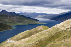
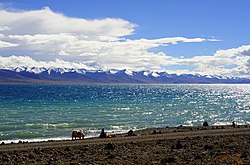
[citation needed] The Tibet AR is dotted over with large and small lakes, generally salt or alkaline, and intersected by streams.
Due to the presence of discontinuous permafrost over the Chang Tang, the soil is boggy and covered with tussocks of grass, thus resembling the Siberian tundra.
The lake region is noted for a vast number of hot springs, which are widely distributed between the Himalaya and 34° N, but are most numerous to the west of Tengri Nor (north-west of Lhasa).
So intense is the cold in this part of Tibet that these springs are sometimes represented by columns of ice, the nearly boiling water having frozen in the act of ejection.
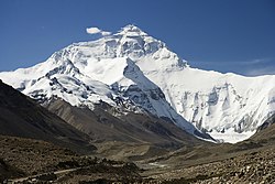
The valleys of Lhasa, Xigazê, Gyantse and the Brahmaputra are free from permafrost, covered with good soil and groves of trees, well irrigated, and richly cultivated.
[citation needed] The South Tibet Valley is formed by the Yarlung Tsangpo River during its middle reaches, where it travels from west to east.
Like other subdivisions of China, routine administration is carried out by a People's Government, headed by a chairman, who has been an ethnic Tibetan except for an interregnum during the Cultural Revolution.
These in turn are subdivided into a total of 66 counties and 8 districts (Chengguan, Doilungdêqên, Dagzê, Samzhubzê, Karub, Bayi, Nêdong, and Seni).
With an average of about two people per square kilometer, Tibet has the lowest population density among any of the Chinese province-level administrative regions, mostly due to its harsh and rugged terrain.
Smaller tribal groups such as the Monpa and Lhoba, who follow a combination of Tibetan Buddhism and spirit worship, are found mainly in the southeastern parts of the region.
[45] The Tibetan government-in-exile based in northern India asserts that the PRC is promoting the migration of Han workers and soldiers to Tibet to marginalize and assimilate the locals.
[54][55] There are four mosques in the Tibet Autonomous Region with approximately 4,000 to 5,000 Muslim adherents,[47] although a 2010 Chinese survey found a higher proportion of 0.4%.
[58] Human rights in Tibet prior to its incorporation into the People's Republic of China differed considerably from those in the modern era.
Due to tight control of press in mainland China, including the Tibet Autonomous Region,[59] it is difficult to accurately determine the scope of human rights abuses.
[69] In general, China's minority regions have some of the highest per capita government spending public goods and services.
By 2023, its gross domestic product (GDP) stood at nearly 239.3 billion yuan (about 33.6 billion U.S. dollars), adding that the growth rates of the region's major economic indicators, including per capita disposable income, fixed asset investment, and total retail sales of consumer goods, all ranked first in China.
[3] In 2022, Tibet's GDP per capita ranked 25th highest in China, as well as higher than any South Asian country except Maldives.
[78] In 2008, Chinese news media reported that the per capita disposable incomes of urban and rural residents in Tibet averaged (CN¥12,482 (US$1,798) and CN¥3,176 (US$457) respectively.
While the main attraction is the Potala Palace in Lhasa, there are many other popular tourist destinations including the Jokhang Temple, Namtso Lake, and Tashilhunpo Monastery.
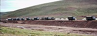
[citation needed] A 2019 white paper from The State Council Information Office of the People's Republic of China reported Tibet's road system has achieved a total of 118,800 km.
Five pairs of passenger trains run between Golmud and Lhasa, with connections onward to Beijing, Chengdu, Chongqing, Guangzhou, Shanghai, Xining and Lanzhou.