Yarra River
Shortly after the arrival of European settlers, land clearing forced the remaining Wurundjeri people into neighbouring territories and away from the river.
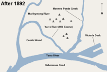
Industrialisation ultimately led to the destruction of the marshlands at the confluence of the Yarra and Maribyrnong Rivers in the area around Coode Island in West Melbourne.
The city reach which is inaccessible to larger watercrafts, has seen increased use for both transport and recreational boating (including kayaking, canoeing, rowing and swimming).
[9] The river was called Birrarung by the Kulin people who occupied the Yarra Valley and much of Central Victoria prior to European colonisation.
[10][11] At European arrival in 1835, Surveyor-General of the Colony of New South Wales John Helder Wedge of the Port Phillip Association visited the area with two Kulin People, who pointed at the flowing water and said yarra yarra, recorded in Wedge's notebook as the phrase yarrow yarrow, in the mistaken belief that this was the name for the river in the Boonwurrung language.
[19][citation needed] The document, commonly called Batman's Treaty, was declared void by the Governor of New South Wales, Richard Bourke.
The new settlement's main port was sited just downstream of Yarra Falls west of modern-day Queen's Bridge, the place where saltwater met freshwater.
Industries then began using the river and tributaries such as Merri Creek as landfill and for harmful chemical dumps for substances like grease and oils.
[21] The objective was to stop people bathing in the Yarra River, which by the 1850s had become quite polluted and the cause of an epidemic of typhoid fever, which hit the city resulting in many deaths.
While this was not considered a problem in the floodplains near Yarra Glen and Coldstream, the floodings caused much trouble further downstream in settlements such as Warrandyte, Templestowe, Bulleen, Heidelberg and Ivanhoe.
The find was made by Louis Michel in 1851 at a tributary of the river, Andersons Creek and marked the start of the Victorian gold rush.
The river was then fully dammed at the entrance and exit to the tunnel and water was diverted through 145m and out the other side leaving a 3.85 km of riverbed around Pound Bend exposed to the sun and the miners picks.
[citation needed] Sections of the river mouth and the area around the former West Melbourne Swamp were widened in the late 19th century, to make way for docks, harbours, bridges and other infrastructure.
This also included widening and deepening, and in some cases, vast areas of land were excavated, such as Victoria Dock, in order to give ease of access for cargo and later container ships.
In 1916, the central pier at Victoria Dock was completed which provided 6 additional shipping berths and cargo sheds and creating a distinctive landmark for Melbourne ports.
[23] This was due mostly to previous storm water drainage works which utilised Elizabeth street as a watercourse during times of intense rain creating flash floods.
By the 1960s there was a growing awareness of the neglect of the Yarra amongst some residents of Melbourne, spawning various community groups and "friends of..." organisations to protect the remnants of the river's ecology.
Growing high density residential development in the lower reaches in the early 1990s coincided with minor government programs such as the installation of litter traps.
The riverside apartment complex Como Centre at South Yarra and the larger urban renewal of the formerly industrial Southbank precinct were both built during the late 1990s.
The Melbourne Docklands urban renewal project began in 2000, comprising mixed use residential and commercial land and recreational boating moors along the river at the disused Victoria Dock and on the south bank of the Yarra.
[26] Early industry located along the river contributed great amounts of pollution such as dangerous chemicals, grease, oil and heavy metals.
[31] Several programs are being implemented to minimise beach and river pollution, mostly organised by community groups, EPA Victoria and local councils.
[36] They are part of the global Waterkeeper Alliance movement and have been involved in forums and discussions pushing for policies to ensure that "the voice" of the river is heard.
The park features extensive stands of mountain ash, a very tall eucalypt, tree ferns, as well as patches of remnant rainforest.
At Healesville, the river turns west again and the stream bed becomes increasingly silty, reducing the clarity of the water, and by the commuter town of Yarra Glen it begins to take on the brownish colour that the lower reaches are known for.
Some small hobby farms are located in the floodplain area of the river, surprisingly close to central Melbourne and almost completely surrounded by suburbs.
Below Dights Falls at Yarra Bend Park in inner Melbourne, the river becomes increasingly estuarine as it passes along the southern side of the central business district.
The lower stretch of the river from Docklands to the Melbourne Cricket Ground was part of the final path of the Queen's Baton Relay of the 2006 Commonwealth Games.
The current course dates back to 1886 when a canal devised by British engineer Sir John Coode was cut from west of Flinders Street to below its junction with the Maribyrnong.
[45] The river is navigable by most boats from its entrance in Hobsons Bay to Dights Falls, a stretch of 22 km (14 mi), and is subject to tidal variations and submerged objects.