Yaxha
Yaxha (or Yaxhá in Spanish orthography) is a Mesoamerican archaeological site in the northeast of the Petén Basin in modern-day Guatemala.
As a ceremonial centre of the pre-Columbian Maya civilization, Yaxha was the third largest city in the region and experienced its maximum power during the Early Classic period (c. AD 250–600).
The name of the city derives from the Mayan for "blue-green water"; it is a notable survival of a Classic period place-name into the modern day.
The Yaxha kingdom is estimated to have covered an area of 237 square kilometres (92 sq mi) and to have had a peak population of 42,000 in the Late Classic period of Mesoamerican chronology.
At this time, in common with other sites in Petén, it shows strong influence from the distant metropolis of Teotihuacan in the Valley of Mexico.
[3] David Stuart first proposed that the emblem glyph of the site should be read Yax-ha and that the name of the city (and the lake) is of ancient origin.
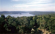
[2] Located in the modern-day department of Petén, northern Guatemala, it is approximately 30 kilometres (19 mi) southeast of Tikal;[4] Yaxha is situated on the north shore of Lake Yaxha;[3] the ruins extend roughly 3 kilometres (1.9 mi) along a hilltop parallel to the lake shore.
[5] The ruins fall within the borders of the Yaxha-Nakum-Naranjo National Park,[6] which encompasses an area of 37,160 hectares (143.5 sq mi) and incorporates the remains of four ancient Maya cities: Yaxha, Topoxte, Nakum and Naranjo, as well as 10 intermediate sites and more than 280 smaller settlements.
[9] Archaeological investigations indicate that the earliest, Middle Preclassic, settlement was in what developed into the southern and western sectors of the city.
In the Late Preclassic the city became the largest settlement in the Yaxha-Sacnab basin, with a marked increase in population and in construction activity.
[12] At the end of the Early Classic, seismic activity caused movement of the Yaxha Fault, resulting in damage to buildings in the East Acropolis.
[14] During this period the city established itself as an important centre on the trade routes that crossed the Petén lakes region.
[8] There is no evidence of the rapid collapse of the Yaxha polity in the Terminal Classic (c. AD 800–900) as took place at other cities in the vicinity.
Some entry controls to the city were removed in order to encourage the flow of visitors to Yaxha from surrounding areas that were more immediately affected by the Classic Maya collapse.
[26] Plaza C is an E-Group astronomical complex to the southeast of the site core,[27] linked to the city centre by the Lincloln Causeway.
[24] Plaza D is in the site core, at the northwest end of the Lincoln Causeway and immediately north of the South Acropolis.
[25] In the Preclassic the East Acropolis was laid out as a triadic pyramid complex but was radically modified during the Early Classic.
During the Terminal Classic (9th century AD) great quantities of ash and domestic ceramics were deposited in the East Acropolis.
[33] The Northeast Acropolis dates back to the Late Preclassic and incorporates an arrangement that includes a triadic pyramid forming a part of an E-Group astronomical complex.
The platform had stepped levels and rounded corners;[6] the principal access appears to have been a stairway on the west half of the north side, which linked Plaza E with Patios 5 and 6 of the acropolis.
[14] An offering was found in the fill under the first chamber of the temple that consisted of seven eccentrics, five of them crafted from obsidian and two from flint, and a piece of mother of pearl.
[21] The earliest version of the building dates to the Early Classic period (Structure 218 sub 1A) and had a long room with a corbel-vaulted roof.
The remains of painted murals were discovered in the interior of the central chamber of the palace, using red, blue, black and yellow pigments.
At this time, during the 9th century AD, a three-chambered building with a perishable roof was built upon the upper platform of the structure; the chambers were linked by doorways.
[42] During the Late Classic the causeway was further developed and extended with the formal construction of Via 5 running across the site core.
The point where the two met was deliberately narrowed with the construction of flanking buildings and is likely to have been a guard post where access to the site core was controlled.
The southern extreme of the causeway was modified with the construction of a stucco-covered platform with masonry walls defining the east and south sides.
The causeway itself was redesigned as a long ramp that joined the southern platform with the city centre and the junction with Via 5.
[30] The style of the stela is that of Teotihuacan, with the sculpted figure of a warrior with the attributes of Tlaloc, the central Mexican rain deity.
[45] The figure bears characteristic eye rings, and a butterfly ornament over the mouth, and wears a feathered headdress.