Yellowstone National Park
[24] When the Lewis and Clark Expedition entered present-day Montana in 1805 they encountered the Nez Perce, Crow, and Shoshone tribes who described to them the Yellowstone region to the south, but they chose not to investigate.
[31] A Montana writer and lawyer named Cornelius Hedges, who had been a member of the Washburn expedition, proposed that the region should be set aside and protected as a national park; he wrote detailed articles about his observations for the Helena Herald newspaper between 1870 and 1871.
[33] Cooke wrote that his friend, Congressman William D. Kelley had also suggested "Congress pass a bill reserving the Great Geyser Basin as a public park forever".
[36] In his report to the Committee on Public Lands, he concluded that if the bill failed to become law, "the vandals who are now waiting to enter into this wonder-land, will in a single season despoil, beyond recovery, these remarkable curiosities, which have required all the cunning skill of nature thousands of years to prepare".
Be it enacted by the Senate and House of Representatives of the United States of America in Congress assembled, That the tract of land in the Territories of Montana and Wyoming ... is hereby reserved and withdrawn from settlement, occupancy, or sale under the laws of the United States, and dedicated and set apart as a public park or pleasuring ground for the benefit and enjoyment of the people; and all persons who shall locate, or settle upon, or occupy the same or any part thereof, except as hereinafter provided, shall be considered trespassers and removed there from ... Approved March 1, 1872.
He addressed the practical problems park administrators faced in the 1872 Report to the Secretary of the Interior[44] and correctly predicted that Yellowstone would become a major international attraction deserving the continuing stewardship of the government.
Yount had previously spent decades exploring the mountain country of present-day Wyoming, including the Grand Tetons, after joining F V. Hayden's Geological Survey in 1873.
[56] The spur line was completed in fall of that year from Livingston to Cinnabar for stage connection to Mammoth, then in 1902 extended to Gardiner station, where passengers also switched to stagecoach.
Rail visitation fell off considerably by World War II and ceased regular service in favor of the automobile around the 1960s, though special excursions occasionally continued into the early 1980s.
With the funding and manpower necessary to keep a diligent watch, the army developed its own policies and regulations that permitted public access while protecting park wildlife and natural resources.
In 1898, the naturalist John Muir described the park as follows: However orderly your excursions or aimless, again and again amid the calmest, stillest scenery you will be brought to a standstill hushed and awe-stricken before phenomena wholly new to you.
In 1963, after several years of public controversy regarding the forced reduction of the elk population in Yellowstone, the United States Secretary of the Interior Stewart Udall appointed an advisory board to collect scientific data to inform future wildlife management of the national parks.
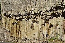
[79] Yellowstone National Park has one of the world's largest petrified forests, trees which were long ago buried by ash and soil and transformed from wood to mineral materials.
[79][80][81] Yellowstone is at the northeastern end of the Snake River Plain, a great bow-shaped arc through the mountains that extends roughly 400 miles (640 km) from the park to the Idaho-Oregon border.
The most violent known eruption, which occurred 2.1 million years ago, ejected 588 cu mi (2,450 km3) of volcanic material and created the rock formation known as the Huckleberry Ridge Tuff and the Island Park Caldera.
[88] A smaller eruption ejected 67 cu mi (280 km3) of material 1.3 million years ago, forming the Henry's Fork Caldera and depositing the Mesa Falls Tuff.
The amount of ash and gases released into the atmosphere probably caused significant impacts on world weather patterns and led to the extinction of some species, primarily in North America.
[96] This coincided with the release of reports of a multiple year United States Geological Survey research project which mapped the bottom of Yellowstone Lake and identified a structural dome that had uplifted at some time in the past.
[98] On March 10, 2004, a biologist discovered 5 dead bison which apparently had inhaled toxic geothermal gases trapped in the Norris Geyser Basin by a seasonal atmospheric inversion.
[99] In 2006, it was reported that the Mallard Lake Dome and the Sour Creek Dome—areas that have long been known to show significant changes in their ground movement—had risen at a rate of 1.5 to 2.4 inches (3.8 to 6.1 cm) per year from mid–2004 through 2006.
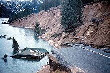
The earthquake caused some geysers in the northwestern section of the park to erupt, large cracks in the ground formed and emitted steam, and some hot springs that normally have clear water turned muddy.
[18] With the successful wolf reintroduction program, which began in the 1990s, much of the original faunal and floral species known to inhabit the region when the first explorers entered the area can be found there.
[133] In September 2018, a U.S. district judge ruled that the grizzly's protections must be restored in full, arguing the Fish and Wildlife Service was mistaken in removing the bear from the threatened status list.
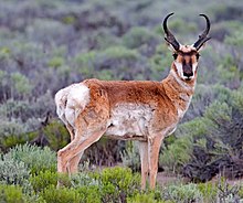
[140] These uncommon and rare mammals provide insight into the health of protected lands such as Yellowstone and help managers make determinations as to how best to preserve habitats.
[145] Other birds, considered to be species of special concern because of their rarity in Yellowstone, include the common loon, harlequin duck, osprey, peregrine falcon and the trumpeter swan.
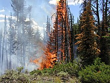
[154] Contrary to media reports and speculation at the time, the fires killed very few park animals—surveys indicated that only about 345 elk (of an estimated 40,000–50,000), 36 deer, 12 moose, 6 black bears, and 9 bison had perished.
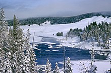
Snow is possible in any month of the year, but most common between November and April, with averages of 150 inches (3,800 mm) annually around Yellowstone Lake, to twice that amount at higher elevations.
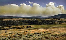
[156] In June 2022, the park closed entrances and evacuated visitors after experiencing record-level rainfall and flooding that caused multiple road and bridge failures, power outages, and mudslides.
In the winter, concessionaires operate guided snowmobile and snow coach tours, though their numbers and access are based on quotas established by the National Park Service.
[193] Circa the 1880s there were education programs for dependent children in the Mammoth area, involving a person hired to teach via money from parents or a soldier providing such services.