Yucatán
The first two state that the name resulted from confusion between the Maya inhabitants and the first Spanish explorers around 1517: Probably the first person to propose the "I do not understand" version was the friar Toribio de Benavente Motolinía.
[21] The origin of the first settlements has not been scientifically confirmed, although the presence of first humans in the area dates from the late Pleistocene or ice age (about 10,000–12,000 years), according to the findings in the Loltún caves and caverns of Tulum (Women of the Palms).
[23][24] In 525, the Chanés (Maya group that preceded the Itza), moved to the east of the peninsula, founding Chichén Itzá, Izamal, Motul, Ek' Balam, Ichcaanzihó (modern Mérida) and Champotón.
(Molina Solís 1896, p. 33) Later, Tutul Xiúes, Toltec descent, who came from the coast of the Gulf of Mexico, settled in the region causing displacement of the Itza and Cocomes—a diversified branch of Itzá—and finally, after years and many battles, the League of Mayapan (composed of the Itza, the Xiús and Cocomes) was formed, which eventually disintegrated circa 1194,[25] giving way to a period of anarchy and fragmentation into small domains which the Spanish conquistadors found in the 16th century.
Bernal Díaz del Castillo places it at Cabo Catoche, where they saw a great city which they named the «Gran Cairo».
Circa 1535, after many bloody battles with the natives, he reached the complete pacification of the Province of Tabasco and began planning his new foray to Yucatán.
In November 1761, Jacinto Canek, a Maya from the town of Cisteil (now located in Yaxcabá Municipality), led an armed uprising against the government, which was quickly put down.
This abortive rebellion was not of great consequence to the colonial regime, but it marked the history of the peninsula and clearly delineated anti-colonial tensions in the region.
The Canek rebellion is remembered today as a symbol of the racial and social conflict that predominated for centuries in the Spanish colonies.
Because of its geographical remoteness from the center of New Spain, especially from Mexico City, Yucatán was not militarily affected by the Mexican War of Independence, though the influence was felt in other ways.
In 1820 Lorenzo de Zavala, member of Sanjuanistas (a group of creoles who met at the church of San Juan in downtown Mérida), created the Patriotic Confederation, which eventually divided into two groups: the supporters of the Spanish government under the Cádiz Constitution and another led by Zavala, which sought outright independence from Spain.
Mariano Carrillo Albornoz then Governor of Yucatán, sent Zavala and Manuel García Sosa as deputies of the Cortes of Cádiz to Madrid, while the other liberals were imprisoned.
While this was happening in Yucatán, the Plan of Iguala was proclaimed in the current state of Guerrero (at that time part of the Intendency of Mexico).
On April 29, 1863, during the government of Mexican President Benito Juárez, Campeche gained its current status as an independent state.
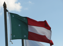
In the green field highlighted, five stars, symbolizing the five departments that Yucatan was divided by decree of November 30, 1840: Mérida, Izamal, Valladolid, Tekax and Campeche.
Today Sisal is a sleepy fishing village, being rediscovered by locals and visitors as a beach location for vacation homes.
The fiber of the henequén plant (known as sosquil (maya: sos kí)) was manufactured into twine and rope, used in riggings, string, sacks, rugs, and many other items.
Labour brokers began advertising in newspapers in the Korean port city of Incheon in 1904 for workers willing to go to Mexico to work on henequen plantations for four- or five-year contracts.
[citation needed] A total of more than one thousand were recruited and departed from Incheon on board a British cargo ship on 4 April 1905, despite efforts by the Korean government to block their departure.
[citation needed] The great influx of wealth during that period from the henequen industry focused mainly on Mérida, the capital of Yucatán State.
Today, Paseo de Montejo (inspired by the Parisian avenue Champs-Élysées), is lined with the elegant houses built during that time.
Until the mid-20th century most of Yucatán's contact with the outside world was by sea; trade with the US and Cuba, as well as Europe and other Caribbean islands, was more significant than that with the rest of Mexico.
Commercial jet airplanes began arriving in Mérida in the 1960s, and additional international airports were built first in Cozumel and then in the new planned resort community of Cancún in the 1980s, making tourism a major force in the economy of the Yucatán Peninsula.
Today, the Yucatán Peninsula is a major tourism destination, as well as home to one of the largest indigenous populations in Mexico, the Maya people.
It borders the states of Campeche to the southwest, Quintana Roo to the east and southeast, and the Gulf of Mexico to the north and west.
In 1905, 1,003 Korean immigrants – 802 men and 231 women and children – departed from the port of Chemulpo, Incheon, aboard the ship Ilford to Salina Cruz, Oaxaca.
Executive power rests in the governor of Yucatán, who is directly elected by the citizens, using a secret ballot, to a six-year term with no possibility of reelection.
[60] The security in the interior of the state was praised multiple times by former president Felipe Calderón Hinojosa,[61] local and foreign businessmen,[62] as well as by governor Ivonne Ortega Pacheco.