Yucca Valley, California
Yucca Valley is an incorporated town in San Bernardino County, California, United States.
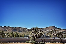
Bordered to the south by the Joshua Tree National Park and to the west by the San Bernardino Mountains, the town of Yucca Valley is located in the Mojave Desert at roughly 3,300 feet (1,000 m) above sea level.
[6] Norman J. Essig was key in the late 1950s in working towards establishing Yucca Valley as a place for entertainment celebrities to come and live in privacy.
He personally acquired hundreds of acres of land during this time and owned and ran Glenn Realty.
He was personal friends with Jimmy Van Heusen the composer and gave him prime real estate in Yucca Valley to build his house which can still be seen atop the highest hill in the center of the town.
The 7.1 magnitude Hector Mine earthquake on October 16, 1999, had an epicenter 30 miles (48 km) north of town.
Yucca Valley is located north of the Joshua Tree National Park, while the Little San Bernardino Mountains and many hills cover a large percentage of city area.
The area's terrain is prone to wildfires (such as the Pioneertown fire in July 2006), resulting from plant growth during the rainy seasons and flash floods.
The plants within the town and among the chaparral in the mountains outside of the San Bernardino National Forest wilt and perish from the summer heat, providing ample fuel during a fire.
According to the 2010 United States Census, Yucca Valley had a median household income of $42,962, with 17.0% of the population living below the federal poverty line.
[15] The California Welcome Center is located at 56711 Twentynine Palms Highway in Yucca Valley; it provides information on where to stay, eat and play while in the area.
Yucca Valley is home to the Desert Christ Park sculpture garden, as well as the geoglyph "Atlatl", created by artist Andrew Rogers.
[17] Yucca Valley contracts its police and public safety services from the San Bernardino County Sheriff's Department.
Yucca Valley has two major means of highway access; California State Route 62 (Twentynine Palms Highway) runs east–west and is the main thoroughfare through town and terminates at the south end at Interstate 10 and Parker Dam on the Arizona border at the east end.
California State Route 247 (Old Woman Springs Road) begins in Yucca Valley and extends north through Barstow and terminates at Interstate 15.
Basin Transit[20] serves the area with scheduled bus service around town and the lower desert.
The service connects passengers to the Palm Springs International Airport direct bus lines to Los Angeles.
WISP (wireless internet service provider) is offered from Mojave WiFi, Frontier and Flashbyte Digital.