Zambezi
Additionally, two smaller power stations are along the Zambezi River in Zambia, one at Victoria Falls and the other in Zengamina, near Kalene Hill in the Ikelenge District.
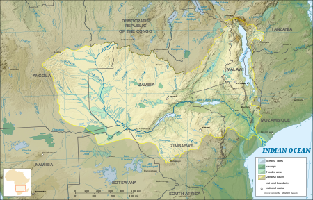
[13] Eastward of the source, the watershed between the Congo and Zambezi Basins is a well-marked belt of high ground, running nearly east–west and falling abruptly to the north and south.
[14] The region drained by the Zambezi is a vast, broken-edged plateau 900–1,200 m high, composed in the remote interior of metamorphic beds and fringed with the igneous rocks of the Victoria Falls.
At Chupanga, on the lower Zambezi, thin strata of grey and yellow sandstones, with an occasional band of limestone, crop out on the bed of the river in the dry season, and these persist beyond Tete, where they are associated with extensive seams of coal.
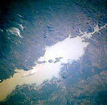
This is the beginning of the Barotse Floodplain, the most notable feature of the upper Zambezi, but this northern part does not flood so much and includes islands of higher land in the middle.
[14] A short distance downstream of the confluence with the Luanginga is Lealui, one of the capitals of the Lozi people, who populate the Zambian region of Barotseland in the Western Province.
[20][citation needed] The lower Zambezi's 650 kilometres (400 mi) from Cahora Bassa to the Indian Ocean is navigable, although the river is shallow in many places during the dry season.
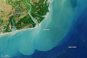
[3] The delta of the Zambezi is today about half as broad as it was before the construction of the Kariba and Cahora Bassa dams controlled the seasonal variations in the flow rate of the river.
[citation needed] Before the dams were built, seasonal flooding of the Zambezi had quite a different impact on the ecosystems of the delta from today, as it brought nutrient-rich fresh water down to the Indian Ocean coastal wetlands.
When heavy rain in the lower Zambezi combines with significant runoff upstream, massive floods still happen, and the wetlands are still an important habitat.
The floodplains are a haven for migratory waterbirds, including pintails, garganey, African openbill (Anastomus lamelligerus), saddle-billed stork (Ephippiorhynchus senegalensis), wattled crane (Bugeranus carunculatus), and great white pelican (Pelecanus onocrotalus).
The north of the Zambezi basin has a mean annual rainfall of 1100 to 1400 mm, which declines towards the south, reaching about half that figure in the south-west.
The rain falls in a 4-to-6-month summer rainy season when the Intertropical Convergence Zone moves over the basin from the north between October and March.
Birds are abundant, with species including heron, pelican, egret, lesser flamingo, and African fish eagle present in large numbers.
[4] Up to the Late Pliocene or Pleistocene (more than two million years ago), the upper Zambezi flowed south through what is now the Makgadikgadi Pan to the Limpopo River.
At a slow rate, the middle Zambezi started cutting back the bed of its river towards the west, aided by grabens (rift valleys) forming along its course in an east–west axis.
Cuama was the local name given by the dwellers of the Swahili coast for an outpost located on one of the southerly islands of the delta (near the Luabo channel).
[citation needed] In 1552, Portuguese chronicler João de Barros noted that the same Cuama River was called Zembere by the inland people of Monomatapa.
[32] In a curious note, Goese-born Portuguese trader Manuel Caetano Pereira, who traveled to the Bisa homelands in 1796, was surprised to be shown a second, separate river referred to as the "Zambezi".
Livingstone records other names for the Zambezi—Luambeji, Luambesi, Ambezi, Ojimbesi, and Zambesi—applied by different peoples along its course, and asserts they "all possess a similar signification and express the native idea of this magnificent stream being the main drain of the country".
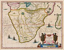
The Zambezi region was known to medieval geographers as the Empire of Monomotapa, and the course of the river, as well as the position of lakes Ngami and Nyasa, were generally accurate in early maps.
[38] The first European to visit the inland Zambezi River was the Portuguese degredado António Fernandes in 1511 and again in 1513, with the objective of reporting on commercial conditions and activities of the interior of Central Africa.
During 1858–60, accompanied by John Kirk, Livingstone ascended the river by the Kongone mouth as far as the falls, and also traced the course of its tributary the Shire and reached Lake Malawi.
Two expeditions led by Major A. St Hill Gibbons in 1895 to 1896 and 1898 to 1900 continued the work of exploration begun by Livingstone in the upper basin and central course of the river.
[49] David Livingstone's Zambezi expedition attempted to open up the river to navigation by paddle steamer, but was defeated by the Cahora Bassa rapids.
[60] As of 2017, the situation of overfishing in the upper Zambezi and its tributaries was considered dire, in part because of weak enforcement of the respective fisheries acts and regulations.
The fish stocks of Lake Liambezi in the eastern Caprivi Strip were found to be depleted, and surveys indicated a decline in the whole Zambezi-Kwando-Chobe River system.
[61] Namibian officials have consequently banned monofilament nets and imposed a closing period of about 3 months every year to allow the fish to breed.
The Namibian ministry also promotes aquaculture and plans to distribute thousands of fingerlings to registered small-scale fish farmers of the region.
Zambia agriculture minister Ben Kapita asked experts to investigate the outbreak to probe the cause to find out if the disease can be transmitted to humans.