120th meridian west
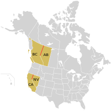
In Canada the border between British Columbia and Alberta is defined by the meridian north of where it intersects the Continental Divide of the Americas, and in the United States part of the border between California and Nevada follows it.
Starting at the North Pole and heading south to the South Pole, the 120th meridian west passes through: When California attained statehood in 1850, it adopted 120th meridian west as its eastern border.
[3] In 1872, Alexey W. Von Schmidt undertook the survey of the state line.
He marked his survey line with stones, wood, and iron markers; the only one who placed such markers[3] A new survey in 1893 showed that the Von Schmidt line was 1,600 to 1,800 feet west of the actual 120 degrees.
[3] Google maps shows that the Verdi, Nevada California–Nevada boundary marker, located at 39°31′28″N 120°00′07″W / 39.52451°N 120.00186°W / 39.52451; -120.00186, is approximately 525 feet (160 m) west of 120 degrees longitude, with a similar deviation along the length of the line from Oregon to Lake Tahoe.