Circle of latitude
For example, the 60th parallel north or south is half as long as the Equator (disregarding Earth's minor flattening by 0.335%), stemming from
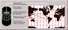
On an equirectangular projection, centered on the equator, the circles of latitude are horizontal, parallel, and equally spaced.
On other cylindrical and pseudocylindrical projections, the circles of latitude are horizontal and parallel, but may be spaced unevenly to give the map useful characteristics.
Arcs of circles of latitude are sometimes used as boundaries between countries or regions where distinctive natural borders are lacking (such as in deserts), or when an artificial border is drawn as a "line on a map", which was made in massive scale during the 1884 Berlin Conference, regarding huge parts of the African continent.
The values below are for 12 February 2025:[2] These circles of latitude, excluding the Equator, mark the divisions between the five principal geographical zones.
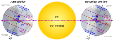
The Arctic Circle is the southernmost latitude in the Northern Hemisphere at which the Sun can remain continuously above or below the horizon for 24 hours (at the June and December solstices respectively).
Similarly, the Antarctic Circle marks the northernmost latitude in the Southern Hemisphere at which the Sun can remain continuously above or below the horizon for 24 hours (at the December and June Solstices respectively).
If the Earth were "upright" (its axis at right angles to the orbital plane) there would be no Arctic, Antarctic, or Tropical circles: at the poles the Sun would always circle along the horizon, and at the equator the Sun would always rise due east, pass directly overhead, and set due west.
The positions of the Tropical and Polar Circles are not fixed because the axial tilt changes slowly – a complex motion determined by the superimposition of many different cycles (some of which are described below) with short to very long periods.
[3]) The Earth's axial tilt has additional shorter-term variations due to nutation, of which the main term, with a period of 18.6 years, has an amplitude of 9.2″ (corresponding to almost 300 m north and south).
Parallels make convenient borders in the northern hemisphere because astronomic latitude can be roughly measured (to within a few tens of metres) by sighting the North Star.