Streets and highways of Washington, D.C.
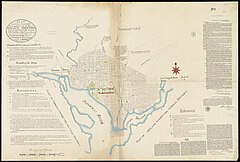
The original street layout in the new City of Washington was designed by Pierre (Peter) Charles L'Enfant.
[3][4] As a planned city, Washington was modeled in the Baroque style and incorporated avenues radiating out from rectangles, providing room for open space and landscaping.
At L'Enfant's request, Thomas Jefferson provided plans of cities such as Amsterdam, Paris, Frankfurt, Karlsruhe and Milan, which he had brought back from Europe in 1788.
[6][7] His design also envisioned a garden-lined "grand avenue" approximately 1 mile (1.6 km) in length and 400 feet (120 m) wide in the area that is now the National Mall.
Though Ellicott made revisions to the original plans, including changes to some street patterns, L'Enfant is still credited with the overall design of the city.
[10][11][12] The district is divided into four quadrants of unequal area: Northwest (NW), Northeast (NE), Southeast (SE), and Southwest (SW).
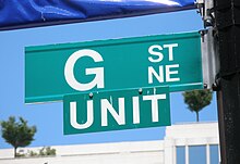
[citation needed] Urban legend had said that J Street was omitted deliberately by L'Enfant due to a dispute with John Jay, the first Chief Justice of the United States Supreme Court; however, this was later proven to be a myth.
[17] During most of the 19th century, each municipality within the federal district maintained its own separate government and street system.
The Commissioners said that "If the configuration and architecture of a city has a moral influence upon its residents, the rectification of the irreclaimable obliquity of the... streets is manifestly desirable for more than physical reasons.
However, the law allowed existing streets to remain, contrary to the wishes of the commissioners of the District of Columbia.
[24] South of the center city, a similar system would be used with streets named after famous Americans or prominent geographical locations.
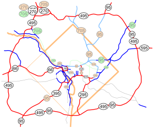
[26] Almost completely circling Washington, D.C., it crosses a tiny portion of the district at its southernmost point at the Woodrow Wilson Bridge.
Just south of the U.S. Capitol Building, I-695 links up with I-395 (the Southwest Freeway), a major commuter route extending from New York Avenue to the Beltway and Interstate 95 in Springfield, Virginia.
A convergence indexing based road traffic monitoring system was installed on Washington's highways in 2008.
[citation needed] The Anacostia Freeway (DC-295) continues in a northeasterly direction from the point where I-295 ends at its intersection with I-695 near the 11th Street Bridges on the south side of the Anacostia River and links with the Baltimore–Washington Parkway, which eventually becomes Maryland Route 295, via a short section of Maryland Route 201.
The Rock Creek and Potomac Parkway provides access to downtown from the northern and western ends of the city.