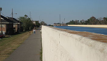
17th Street Canal
The 17th Street Canal forms a significant portion of the boundary between the city of New Orleans and Metairie, Louisiana.
Meanwhile, in 1858, a secondary canal was built to aid in drainage in the low swampy area in "back of town" from Carrollton, with its head at what is now the intersection of Dublin and Palmetto streets, connecting to the Railway canal a short distance on the river side of the Metairie Ridge.
In 1899 a new pumping station was opened atop the Canal a couple blocks back from Metairie Road.
)[1] At about 6:30 am on August 29, 2005, a portion of the I-wall along the east side of the 17th Street Canal adjacent to the 6900 block of Bellaire Drive split open, sending torrents of water into New Orleans' Lakeview neighborhood.
The breach released storm-surge floodwaters that destroyed buildings, homes, and infrastructure, throughout all but the highest areas within the city.
Thirty-one (31) victims were recovered from areas directly flooded due to the breach of the 17th Street Canal levee.
[3] On November 10, 2005, an article in the Times-Picayune revealed that sonar soundings discovered that the steel sheet pilings of the levee flood wall were 2.1 m (7 ft) less deep than engineering specifications.
According to an article published in the August 2015 issue of the official journal of the World Water Council, the Army Corps of Engineers misinterpreted the results of a Sheet Pile Load test (E-99 Study) conducted in the mid-1980s and concluded they needed to drive sheet pilings to depths of not more than 17 feet, rather than the necessary 31 to 46 feet.
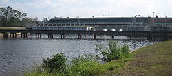
As a temporary measure, the corps constructed storm-surge barrier gates and an interim pump station at the lake end of the canal.
[5] In June 2008, plans were announced by the Corps of Engineers to clear private land for access to the flood wall and levee.
On July 7, 2008, a state court judge ruled the Corps could continue, but that property owners could seek compensation.
[6] Plans to clear encroachments on the west (Jefferson Parish) side of the canal were to begin with field surveys in early 2009.
[8] In August 2010, the grassroots group Levees.org installed a plaque, vetted and fact checked by the Louisiana State Office of Historic Preservation, at the levee breach site.