Hurricane Georges
Effects Other wikis Hurricane Georges (/ʒɔːrʒ/) was a powerful and long-lived tropical cyclone which caused severe destruction as it traversed the Caribbean and Gulf of Mexico in September 1998, making seven landfalls along its path.
A strong upper-level ridge forced the depression to the west-northwest, where warm water temperatures allowed it to strengthen to a tropical storm on September 16.
[1] Conditions became nearly ideal for continued development, including warm water temperatures, low-level inflow to the hurricane's north, and good upper-level outflow.
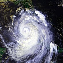
[1] On September 21, after weakening considerably, Category 3 Georges made landfall directly on Antigua and three hours later in St. Kitts, though its 175 mi (282 km) wide tropical storm force wind field affected all the Leeward Islands.
Over the mountainous terrain of the island, the hurricane weakened again, but over the Mona Passage it again re-intensified to hit eastern Dominican Republic with winds of 120 mph (190 km/h) on September 22.
Like in Puerto Rico, Georges was greatly weakened by the mountainous terrain, and after crossing the Windward Passage, it struck 30 mi (48 km) east of Guantánamo Bay, Cuba on September 23.
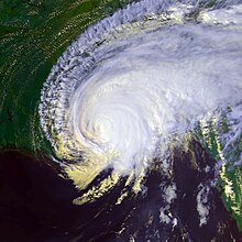
A mid-tropospheric anticyclone pushed the hurricane slowly north-northwestward, forcing Georges to make its seventh and final landfall near Biloxi, Mississippi on September 28.
Within 24 hours, Georges had weakened to a tropical depression, and due to weak steering currents, the storm looped over southern Mississippi, then drifted to the east.
[1] Late on September 18, a hurricane watch was issued for Saint Lucia, Anguilla, Saba, and Sint Maarten; it was extended to include the British and United States Virgin Islands on the following day.
Puerto Rican governor Pedro Rosselló activated the island's National Guard, opened 416 shelters, and enacted a temporary prohibition on alcohol sales.
Both the Federal Emergency Management Agency (FEMA) and the American Red Cross deployed workers there with supplies for a potentially deadly event.
[9] In the northern Gulf of Mexico, Georges was forecast to attain major hurricane status and make landfall in southeastern Louisiana.
[1] Upon moving through the Leeward Islands, Georges brought strong winds and heavy rainfall, amounting to a maximum of 7.5 inches (190 mm) at St.
[21] The weakening hurricane spared the island as it passed 27 miles (43 km) to the north, causing moderate damage (houses and roofs, uprooted trees, power lines and outages, beach erosion) especially in Grande-Terre.
Many schools, businesses, hospitals, and government buildings lost their roofs, while the airport experienced severe damage to its main terminal and control tower, limiting flights to the daytime.
[12] As Georges moved through the northern end of the Lesser Antilles, it produced significant rainfall and strong winds over the United States Virgin Islands.
Nearly 10 hours of continuous rainfall resulted in mudslides and overflown rivers across the mountainous country, damaging many cities along the southern coastline, including the capital.
The capital city of Port-au-Prince was largely unharmed, with the exception of flooding in low-lying coastal areas, damaging the main commercial port.
[40] On the southern coast, the head of a U.S.-based medical team, stranded for several days by flooding in the remote town of Belle Anse, anticipated a rise in malnutrition, disease, homelessness and poverty.
[41][42] Lack of electricity led to a total disruption of Haiti's water supply system, causing a decrease in sanitary conditions across the poorest country in the Western Hemisphere.
[37] Upon making landfall, Hurricane Georges produced torrential rainfall, amounting to a maximum of 24.41 inches (620 mm) at Limonar in the province of Guantánamo.
[46] High winds downed power lines, trees, and telephone poles, leaving many in eastern Cuba without electricity in the aftermath of the storm.
Though eastern Cuba was the area most affected, the central and western portion of the island, including Havana, experienced torrential rains and strong wind gusts.
[51] As the storm moved slowly through the northern Gulf Coast, it produced torrential rainfall amounting to a maximum of 38.46 in (977 mm) in Munson, causing extensive inland flooding.
[1] Upon making landfall in Mississippi, Georges brought a storm surge peaking at 8.9 ft (2.7 m) near Pointe a la Hache, along with higher waves on top of it, though the instrument failed shortly after the observation.
Two men collapsed and died due to medical conditions aggravated by the stress of the evacuation; the other death occurred as the result of a house fire ignited by an emergency candle that was tipped over.
The most devastating tornado touched-down in Enterprise, causing severe damage to Camp Wiregrass and a few homes, while many residences in the city were left without electricity after numerous power lines were downed.
[26]: 34 Another intense thunderstorm in Worth County impacted several residences, knocked a mobile home off its foundation, destroyed a barn, overturned a school bus, and downed a number of trees that fell onto power lines, leaving around $350,000 in damage.
The most damaging tornado occurred in Miller County, with a strong F1 destroying a doublewide trailer, seriously injuring two occupants, and deroofing several outbuilding, twisting sheet metal, and demolishing a grain bin.
[26]: 35 Due to the extensive hurricane related damage and loss of life, the name Georges was retired by the World Meteorological Organization following this storm, and will never again be used for a North Atlantic tropical cyclone.

Tropical storm (39–73 mph, 63–118 km/h)
Category 1 (74–95 mph, 119–153 km/h)
Category 2 (96–110 mph, 154–177 km/h)
Category 3 (111–129 mph, 178–208 km/h)
Category 4 (130–156 mph, 209–251 km/h)
Category 5 (≥157 mph, ≥252 km/h)
Unknown