1971 Inverness tornado
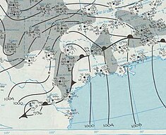
Multiple days before the event, upper-level analysis displayed conditions that were "close to ideal" for a significant tornado outbreak.
A large upper-level trough situated across the Rockies, with a substantial eastward motion toward the Great Plains, leading to significant divergence over the prefrontal warm sector.
This divergence caused a significant lifting mechanism that storms could take advantage of, but surface-based shortwave meteorology was still very new, and subsequently, it was unknown how the system would behave further in the week.
The tornado was most likely moving at over 50 mph as it approached Highway 80 from the south flattening swaths of trees, and witnesses described it as looking like "a thousand hells."
As the tornado continued, a large church to the northeast was flattened, and a steel transmission tower was crumpled to the ground before the vortex tracked through miles of forest, impacting multiple small farms and homes north of Waverly, LA.
Further into Mississippi, the tornado's wind field reached a width of 2,000 yards, snapping trees and destroying or damaging dozens of rural homes in Issaquena County.
The core of the tornado was now producing significant ground scouring to fields, and impacted trees were obliterated, and partially debarked.
[4] As the tornado crossed Highway 61, the large Cameta Plantation was directly impacted as well as multiple shops, homes, and metal buildings nearby.
Clusters of farmsteads and homes were destroyed southwest of Delta City, before the tornado would make a direct impact on the village at 4:10 PM CDT.
Despite significant warning given by the National Weather Service, the community was predominantly low-income, and structures were poorly constructed, leading to increased fatalities.
The tornado then crossed through 4th Street into the heart of downtown Inverness, where more businesses were destroyed, including several important government buildings and economic sources.
Two churches lost roofing and walls, cars were tossed into trees, and farm equipment was mangled as the tornado finally exited Inverness.
[3][9][10][11] Exiting Inverness, spaced out residences along Mound Bayou were significantly damaged or destroyed, and ground scouring and wind-rowing of debris was observed once again.
The vortex began to weaken slightly as it maintained itself through open farmland and forest, snapping trees and damaging a couple of structures.
Poorly anchored structures suffered wall collapses as the tornado tracked through town, but damage remained minimal.