1975 Omaha tornado outbreak
The costliest of these tornadoes struck parts of western Omaha, Nebraska, causing at least $150 million in damage and killing three people.
It was at the time the costliest tornado in U.S. history, damaging over a thousand homes across a nearly 2,000-block area on its roughly 15 mi (24 km) long path.
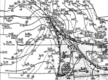
The tornadoes were produced by thunderstorms moving across a narrow region of warm and moist air that had advanced northwards into the Upper Midwest as a result of a strong area of low pressure over South Dakota.
The tornado outbreak was associated with an intense area of low pressure that moved from Colorado into South Dakota beneath a strong upper-tropospheric trough.
The combination of the low-pressure system and a ridge of high pressure over the Great Lakes moved unstable air in the lower levels of the troposphere towards eastern Nebraska.
[2] An ongoing scientific field campaign run by NASA – Atmospheric Variability Experiments – sampled environmental conditions throughout the southwestern and southern United States during the eventual severe weather event.
[11] The National Severe Storms Forecast Center (NSSFC) issued a tornado watch for much of the area in advance of the event at 12:37 p.m. May 6.
[20] All but one of the tornadoes had relatively short tracks, with their parent thunderstorms moving across the narrow corridor of moist air and the steep temperature gradient accompanying the warm front; the storm that produced the long-track tornado moved parallel to the temperature gradient.
[1] A destructive tornado – at the time the costliest in U.S. history – impacted residential areas of west-central Omaha on the afternoon of May 6, tracking primarily south to north along 72nd Street.
[12] The tornado's path began in a largely rural area near the intersection of Nebraska Highway 370 and 132nd Street in northern Sarpy County.
Moving northeast, the tornado struck parts of northwestern Ralston, damaging neighborhoods and businesses near 84th and L streets.
Numerous buildings sustained significant damage near the intersection of 72nd and Dodge streets, including the Nebraska Furniture Mart.
[27] The Omaha Community Playhouse lost most of its roof and the Downtowner Motor Inn suffered major damage.
[12] The swath of damage ranged from about 0.25–0.5 mi (0.40–0.80 km) wide,[30] spanning two to six city blocks at a time.