Surface weather analysis
Use of the Norwegian cyclone model for frontal analysis began in the late 1910s across Europe, with its use finally spreading to the United States during World War II.
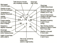
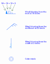
Surface weather analyses have special symbols that show frontal systems, cloud cover, precipitation, or other important information.
The use of weather charts in a modern sense began in the middle portion of the 19th century in order to devise a theory on storm systems.
[3] The development of a telegraph network by 1845 made it possible to gather weather information from multiple distant locations quickly enough to preserve its value for real-time applications.
The use of frontal zones on weather maps did not appear until the introduction of the Norwegian cyclone model in the late 1910s, despite Loomis' earlier attempt at a similar notion in 1841.
[8] Despite the introduction of the Norwegian cyclone model just after World War I, the United States did not formally analyze fronts on surface analyses until late 1942, when the WBAN Analysis Center opened in downtown Washington, D.C.[9] The effort to automate map plotting began in the United States in 1969,[10] with the process complete in the 1970s.
[13] Recent advances in both the fields of meteorology and geographic information systems have made it possible to devise finely tailored weather maps.
Polar lows can form over relatively mild ocean waters when cold air sweeps in from the ice cap.
Under surface highs, sinking of the atmosphere slightly warms the air by compression, leading to clearer skies, winds that are lighter, and a reduced chance of precipitation.
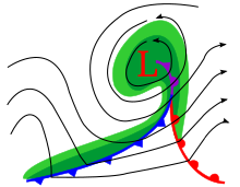
Fronts classically wrap around low pressure centers as indicated in the image here depicted for the northern hemisphere.
On a larger scale, the Earth's polar front is a sharpening of the general equator-to-pole temperature gradient, underlying a high-altitude jet stream for reasons of thermal wind balance.
On a weather map, the surface position of the cold front is marked with a blue line of triangles (pips) pointing in the direction of travel, at the leading edge of the cooler air mass.
On weather maps, the surface location of a warm front is marked with a red line of half circles pointing in the direction of travel.
[25] A more modern view suggests that they form directly during the wrap-up of the baroclinic zone during cyclogenesis, and lengthen due to flow deformation and rotation around the cyclone.
[26] Occluded fronts are indicated on a weather map by a purple line with alternating half-circles and triangles pointing in direction of travel: that is, with a mixture of warm and cold frontal colors and symbols.
Occluded fronts are indicated on a weather map by a purple line with alternating half-circles and triangles pointing in direction of travel.
[29] Often a less-steep temperature gradient continues behind (on the cool side of) the sharp frontal zone with more widely spaced isotherms.
A wide variety of weather can be found along a stationary front, characterized more by its prolonged presence than by a specific type.
Stationary fronts are marked on weather maps with alternating red half-circles and blue spikes pointing in opposite directions, indicating no significant movement.
[33] When the warm moist air wedged under the drier mass heats up, it becomes less dense and rises and sometimes forms thunderstorms.
[citation needed] During daylight hours, drier air from aloft drifts down to the surface, causing an apparent movement of the dryline eastward.
The resultant mesoscale convective system (MCS) forms at the point of the upper level split in the wind pattern at the area of the best low-level inflow.
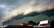
When the convection is strong and linear or curved, the MCS is called a squall line, with the feature placed at the leading edge where the significant wind shifts and pressure rises.
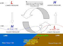
This process usually reverses at night where the water temperature is higher relative to the landmass, leading to an offshore land breeze.
[citation needed] If enough moisture exists, thunderstorms can form along sea breeze fronts that then can send out outflow boundaries.


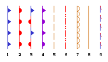
1. cold front
2. warm front
3. stationary front
4. occluded front
5. surface trough
6. squall line
7. dry line
8. tropical wave
9. Trowal