1979 Coyote Lake earthquake
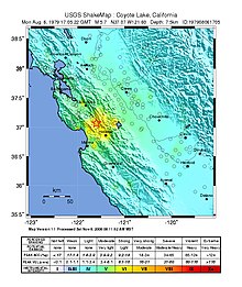
The 1979 Coyote Lake earthquake occurred at 10:05:24 local time on August 6 with a moment magnitude of 5.7 and a maximum Mercalli Intensity of VII (Very strong).
The shock occurred on the Calaveras Fault near Coyote Lake in Santa Clara County, California and resulted in a number of injuries, including some that required hospitalization.
A non-destructive aftershock sequence that lasted throughout the remainder of the month was of interest to seismologists, especially with regard to fault creep, and following the event local governments evaluated their response to the incident.
It terminates in the south in a more gradual fashion at the Salton Sea, where displacement transitions to a series of transform faults and spreading centers along the Gulf of California Rift Zone.
Although the Hayward Fault Zone is also nearby, making this an area of regular seismic activity, no observable foreshocks occurred within the preceding three months.
A large number of strong motion stations recorded the event, including an array of units along the rupture zone, and instruments at the Berkeley Seismological Laboratory.
[8] At the most extreme points of its perceptibility, it was felt with intensity II or III (Weak) at Healdsburg in the north and Santa Barbara in the south, Visalia in the central valley and Twain Harte in the Sierra Nevada foothills.
A survey of the aftershock activity used data from these stations, along with a custom crustal velocity model, to narrow epicenter locations to within several tens of meters.
Local authorities had trained for disasters on a regular basis, and the response to the light damage was considered smooth, though some officials sought room for improvement.