1991 Perfect Storm
The nor'easter received the name, playing off the common expression, after a conversation between Boston National Weather Service forecaster Robert Case and author Sebastian Junger.
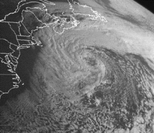
The storm lashed the east coast of the United States with high waves and coastal flooding before turning to the southwest and weakening.
Most of the damage occurred while the storm was extratropical, after waves up to 30 feet (10 m) struck the coastline from Nova Scotia to Florida and southeastward to Puerto Rico.
A buoy off the coast of Nova Scotia reported a wave height of 100.7 feet (30.7 m), the highest ever recorded in the province's offshore waters.
Off the shore of New York's Long Island, an Air National Guard helicopter ran out of fuel and crashed; four members of its crew were rescued and one died.
Around that time, a ridge extended from the Appalachian Mountains northeastward to Greenland, with a strong high pressure center over eastern Canada.
[3] The cyclone significantly strengthened as a result of the temperature contrast between the cold air to the northwest, and the warmth and moisture from the remnants of Grace.
[5] While situated about 390 miles (630 km) south of Halifax, Nova Scotia, the storm attained its peak intensity with winds of up to 70 mph (110 km/h).
[3] Upon peaking in intensity, the nor'easter turned southward and gradually weakened; by November 1, its pressure had risen to 998 millibars (29.5 inHg).
The low moved over warm waters of the Gulf Stream, where bands of convection around the center began to organize.
On November 1, while the storm was moving in a counter-clockwise loop, a tropical cyclone had been identified at the center of the larger low.
)[10] By around 14:00 UTC on November 1, an eye feature was forming, and the tropical cyclone reached its peak intensity with maximum sustained winds of 75 mph (121 km/h);[11][12] these estimates, combined with reports from an Air Force Reserve Unit flight into the storm and confirmation that a warm-core center was present, indicated that the system had become a Category 1 hurricane on the Saffir–Simpson Hurricane Scale.
While the storm was approaching the coast, weather radars depicted curved rainbands on the western side of the system.
[5][16] In North Carolina, the National Weather Service offices in Hatteras and Raleigh first issued a heavy surf advisory on October 27, more than eight hours before the first reports of high waves.
The Hatteras NWS office ultimately released 19 coastal flood statements, as well as media reports explaining the threat from the wind and waves, and a state of emergency was declared for Dare County, North Carolina.
[4] Other National Weather Service offices were tasked with issuing warnings for this storm in lieu of the typical NHC advisories.
This was done to avoid confusion among the media and the public, who were focusing on the damage from the initial nor'easter, as the hurricane itself was not expected to pose a major threat to land.
[20] The Halloween Storm of 1991 left significant damage along the east coast of the United States, primarily in Massachusetts and southern New Jersey.
[2] Over a three-day period, the storm lashed the northeastern United States with high waves,[6] causing damage to beachfront properties from North Carolina to Maine.
The total without power was much less than for Hurricane Bob two months prior, and was fairly low due to little rainfall and the general lack of leaves on trees.
After encountering high seas in the middle of the storm, the vessel made its last radio contact late on October 28, about 180 miles (290 km) northeast of Sable Island.
[26] The American Red Cross opened service centers in four locations in Massachusetts to assist the storm victims by providing food, clothing, medicine, and shelter.
The agency deployed five vehicles carrying cleanup units and food, and allocated $1.4 million to provide assistance to 3,000 families.
In Nova Scotia, where the storm made landfall, precipitation reached 1.18 in (30 mm), and 20,000 people in Pictou County were left without power.
[30] In New York and northern New Jersey, the storm system left the most coastal damage since the 1944 Great Atlantic hurricane.
Across the area, tide heights reached their highest since the 1944 hurricane, leaving severe coastal and back bay flooding and closing many roads.
[5] Fire Island National Seashore was affected, washing away an entire row of waterfront houses in towns like Fair Harbor.
Later, the extratropical predecessor to the unnamed hurricane produced additional high waves, causing oceanfront flooding from Cape Hatteras through the northern portions of Currituck County.
[22] Nags Head, Kitty Hawk, and Kill Devil Hills had large portions covered with water for several blocks away from the beach.
[3] In Puerto Rico, waves of 15 ft (4.6 m) affected the island's north coast, which prompted 32 people to seek shelter.

Tropical storm (39–73 mph, 63–118 km/h)
Category 1 (74–95 mph, 119–153 km/h)
Category 2 (96–110 mph, 154–177 km/h)
Category 3 (111–129 mph, 178–208 km/h)
Category 4 (130–156 mph, 209–251 km/h)
Category 5 (≥157 mph, ≥252 km/h)
Unknown