Subtropical cyclone
Across the north Atlantic and southwest Indian Ocean, they require some central convection fairly near the center surrounding a warming core existing in the mid-levels of the troposphere.
Across the eastern half of the northern Pacific however, they require a mid-tropospheric cyclone to be cut off from the main belt of the westerlies and with only a weak surface circulation.
This also means that subtropical cyclones are more likely to form outside the traditional bounds of the North Atlantic hurricane season and at higher latitudes.
[8] In the north Atlantic basin, subtropical cyclones were initially named from the NATO phonetic alphabet list in the early to mid-1970s.
[6] In the intervening years of 1975–2001, subtropical storms were either named from the traditional list and still was considered tropical in real-time, or used a separate numbering system instead.
[10] In the southern Indian Ocean, subtropical cyclones are also named once winds reach tropical storm or gale force.
[12] Subtropical cyclones can form in a wide band of latitude, mainly south of the 50th parallel in the northern hemisphere.
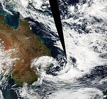
In the case of the north Indian Ocean, the formation of this type of vortex leads to the onset of monsoon rains during the wet season.
The initial thunderstorm activity humidifies the environment around the low pressure system, which destabilizes the atmosphere by reducing the lapse rate needed for convection.
[1][17] If the thunderstorm activity becomes deep and persistent, allowing its initial low level warm core to deepen, extension to tropical cyclogenesis is possible.
[13] The locus of formation for north Atlantic subtropical cyclones is out in the open ocean; the island of Bermuda is regularly impacted by these systems.
A second mechanism for formation has been diagnosed for south Atlantic subtropical cyclones: lee cyclogenesis in the region of the Brazil Current.
[4] Subtropical cyclone formation is extremely rare in the far southeastern Pacific Ocean, due to the cold sea-surface temperatures generated by the Humboldt Current and unfavorable wind shear.
[25][2][26] Subtropical cyclones with hurricane-force winds of 33 m/s, (119 km/h, 64 knots, or 74 mph) or greater are no longer recognized by the National Hurricane Center.
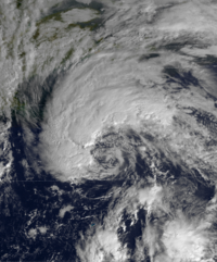
Examples during the 21st century in the north Atlantic include: The most common type of subtropical storm is an upper-level cold low with circulation extending to the surface layer and maximum sustained winds generally occurring at a radius of about 160 kilometers (99 mi) or more from the center.
A definition change in the term during the early 1970s makes categorization of the systems more complex, as many kona lows are extratropical cyclones, complete with their own weather fronts.