Extratropical cyclone
Extratropical cyclones are capable of producing anything from cloudiness and mild showers to severe hail, thunderstorms, blizzards, and tornadoes.
These types of cyclones are defined as large scale (synoptic) low pressure weather systems that occur in the middle latitudes of the Earth.
[5] A separate study in the Northern Hemisphere suggests that approximately 234 significant extratropical cyclones form each winter.
Initially, cyclogenesis, or low pressure formation, occurs along frontal zones near a favorable quadrant of a maximum in the upper level jetstream known as a jet streak.
When pressures fall more than 1 millibar (0.030 inHg) per hour, the process is called explosive cyclogenesis, and the cyclone can be described as a bomb.
[8][9][10] These bombs rapidly drop in pressure to below 980 millibars (28.94 inHg) under favorable conditions such as near a natural temperature gradient like the Gulf Stream, or at a preferred quadrant of an upper-level jet streak, where upper level divergence is best.
[11] On 14 and 15 December 1986, an extratropical cyclone near Iceland deepened to below 920 millibars (27 inHg),[12] which is a pressure equivalent to a category 5 hurricane.
However, after transition is complete, the storm may re-strengthen due to baroclinic energy, depending on the environmental conditions surrounding the system.
[27] The technique is applied when a tropical cyclone interacts with a frontal boundary or loses its central convection while maintaining its forward speed or accelerating.
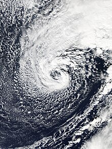
Due to their appearance on satellite images, extratropical cyclones can also be referred to as frontal waves early in their life cycle.
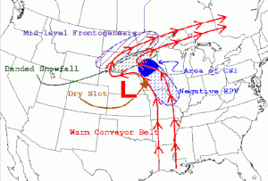
[32] In the northern hemisphere, once a cyclone occludes, a trough of warm air aloft—or "trowal" for short—will be caused by strong southerly winds on its eastern periphery rotating aloft around its northeast, and ultimately into its northwestern periphery (also known as the warm conveyor belt), forcing a surface trough to continue into the cold sector on a similar curve to the occluded front.
The trowal creates the portion of an occluded cyclone known as its comma head, due to the comma-like shape of the mid-tropospheric cloudiness that accompanies the feature.
[33] Extratropical cyclones slant back into colder air masses and strengthen with height, sometimes exceeding 30,000 feet (approximately 9 km) in depth.
In this theory, cyclones develop as they move up and along a frontal boundary, eventually occluding and reaching a barotropically cold environment.
[citation needed] Warm seclusions may have cloud-free, eye-like features at their center (reminiscent of tropical cyclones), significant pressure falls, hurricane-force winds, and moderate to strong convection.
[citation needed] As latent heat flux releases are important for their development and intensification, most warm seclusion events occur over the oceans; they may impact coastal nations with hurricane force winds and torrential rain.
[citation needed] Changes in direction of this nature are most commonly observed as a result of a cyclone's interaction with other low pressure systems, troughs, ridges, or with anticyclones.
[47] The precise results of such interactions depend on factors such as the size of the two cyclones, their strength, their distance from each other, and the prevailing atmospheric conditions around them.
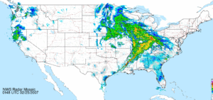
In mature extratropical cyclones, an area known as the comma head on the northwest periphery of the surface low can be a region of heavy precipitation, frequent thunderstorms, and thundersnows.
[49] When significant directional wind shear exists in the atmosphere ahead of a cold front in the presence of a strong upper-level jet stream, tornado formation is possible.
[51] Although most tropical cyclones that become extratropical quickly dissipate or are absorbed by another weather system, they can still retain winds of hurricane or gale force.
[52] In summer, extratropical cyclones are generally weak, but some of the systems can cause significant floods overland because of torrential rainfall.
[citation needed] The existence of such transients are also closely related to the formation of the Icelandic and Aleutian Low — the two most prominent general circulation features in the mid- to sub-polar northern latitudes.
[57][58] The same Geophysical Research Letters article notes at least five other extratropical cyclones in the Southern Ocean with a pressure under 915 mbar (27.0 inHg).
[58] In the North Atlantic Ocean, the most intense extratropical cyclone was the Braer Storm, which reached a pressure of 914 mbar (27.0 inHg) in early January 1993.
[59] Before the Braer Storm, an extratropical cyclone near Greenland in December 1986 reached a minimum pressure of at least 916 mbar (27.0 inHg).
[61][62] In October 2021, the most intense Pacific Northwest windstorm occurred off the coast of Oregon, peaking with a pressure of 942 mbar (27.8 inHg).
[67][68] In late December 1999, Cyclones Lothar and Martin caused 140 deaths combined and over $23 billion in damages in Central Europe, the costliest European windstorms in history.
[81] In September 1954, the extratropical remnants of Typhoon Marie caused the Tōya Maru to run aground and capsize in the Tsugaru Strait.