1997 Red River flood
Grand Forks mayor Pat Owens had to order the evacuation of more than 50,000 people, most of the population of the city, as a huge area was flooded.
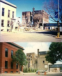
A large fire started in downtown Grand Forks, engulfing eleven buildings and sixty apartment units before being extinguished.
In the aftermath, the Federal Emergency Management Agency (FEMA) worked with the cities of Grand Forks and East Grand Forks to clear residential and business development from a large area of floodplain, because of the certainty of future regional floods, and also as the floodplain is intended to be a natural means to absorb floodwaters.
They also redeveloped the floodplain along the river as the Greater Grand Forks Greenway, including several parks, a Minnesota state campground recreation area, and a 20-mile biking and walking trail.
The Red River Floodway, an artificial waterway completed in 1968 and nicknamed "Duff's Ditch", exceeded its capacity flow but managed to divert the floodwaters around Winnipeg which minimized damage.
It is highly prone to spring flooding because of its northward flow, the nearly flat former lake bed of the valley, and ice formation on the river.
The wide flatness of the terrain, formed from an ancient lake bed, and the low slope of the river also contribute to severe flooding in the region.
The National Weather Service (NWS) had forecast that the river would crest at 49 feet (14.9 m),[4] which was its highest level during the 1979 flood.
[4][6] The dikes in the low-lying Lincoln Drive neighborhood of Grand Forks were the first to break, doing so early on April 18, as the river kept rising.
To compensate, the province broke operational rules for the Floodway, as defined in legislation, during the night of April 30 / May 1, to prevent waters in Winnipeg from rising above the designed limit of 24.5 ft (7.5 m) above the "James Avenue datum", but causing additional flooding upriver.
Winnipeg Mayor Susan Thompson, announcing that the design limit had been reached, misinterpreted this as good news that the flooding had peaked.
[20][21] Towns upriver of Winnipeg, forewarned by footage of buildings in Grand Forks burning and covered in meters of water, built ring dikes to protect their homes and properties.
[17] An emergency 42 km (26 mi) long dike, later called the Brunkild Z-dike, was constructed in a matter of days when officials realized that overland flooding threatened the city of Winnipeg.
"[16] While the flooding was still underway, the federal Liberal government led by Jean Chrétien called a snap election.
[24][25] In July, Canadian Prime Minister Jean Chrétien and United States President Bill Clinton appointed the International Red River Basin Task Force, comprising members from both countries.
Following the flood, Catastroffiti, a form of graffiti related to natural disasters, started to appear as affected residents gutted their houses, placing damaged materials on the berms.
[27] Post-flood emotions driving this largely consisted of frustration with the National Weather Service after it predicted a flood crest about five feet less than the actual.