2009 Red River flood
The flood was a result of saturated and frozen ground, spring snowmelt exacerbated by additional rain and snow storms, and virtually flat terrain.
[16] A levee in Georgetown, Minnesota was raised another two feet, and emergency dikes were being built in Fargo, Moorhead, Harwood, Grafton and Richland County.
[19] By March 24, the National Weather Service predicted the crest in Wahpeton and Breckenridge not to top 18 feet (5.5 m), below the cities' levees.
The snowstorm that struck March 9–10 raised the predicted levels between 47 and 50 feet (14 and 15 m) prompting the city to declare a state of emergency.
Several towns and R.M.s declared a state of emergency due to the ice jams built up in places along the Red.
[22] An eight-year-old boy fell into the river on Thursday, April 9 on the Westroc Hutterite Colony which is near Portage la Prairie.
The team under Murray Kesselman, director of the Health Sciences Centre pediatric intensive care unit, worked on Gross's heart for two hours before it started to beat on its own and he began to recover.
[24][25] Walter Imbeck, 68 years old, went missing since April 11 when friends and neighbours thought he was trying to clear a broken drain behind his home, which was along the riverbank.
[26] As of April 13, several communities north of Winnipeg had to be evacuated due to flash flooding and ice jams on the Red River.
A 79-year-old woman, Mary, died, and her 82-year-old husband, Glen Silverthorn, went missing Easter Sunday after their car was swept into the Woody River.
"We'd look at voluntary buyouts as the first option, but the municipalities have raised this ...they're the ones that have to send in first responders and rescue crews," said Steve Ashton, the province's Emergency Measures Minister.
Peguis Chief Glen Hudson estimated the evacuation and dike construction for the first nation reserve was pegged at approximately $3 million.
[42] At 2:30 a.m. CDT on March 27, the National Weather Service offices in Grand Forks issued a Flash Flood Warning for extreme east-central Cass County due to a levee breach in Fargo on Lindenwood Drive.
[48] While the jam was broken, it reformed near Lower Fort Garry, causing the water to rise 4.5 meters (15 feet) in 2 hours.
On Thursday, March 26, some 95 elderly and special needs people were evacuated from the Roseau River Anishinabe First Nation.
There were three million sandbags, rolls of poly film Hesco bastion flood walls, and water pumps sent out by the U.S. Army Corps of Engineers to North Dakota.
[54] The North Dakota National Guard used 160 pounds (73 kg) of C-4 plastic explosives on the 3-foot-thick (0.91 m) ice placed into 80 holes.
[56] Manitoba purchased five new certified emergency response trailers (CERTs), which are 15-meter-long (49 ft) tubes with 60 compartments which can be filled with water and used to build dikes.
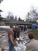
[57] Volunteers created over 600,000 sandbags to shore up defences against the Red River and unpredictable flows caused by ice jams.
[63] Sightseers traveling by car, boat, kayak and anyone ignoring road closures were being ticketed by the Royal Canadian Mounted Police as they were hampering ice clearing operations.
[55] Rural municipality reeves have approached the Canadian government with a CA$288,000 plan which would use the province of Manitoba's existing Amphibex ice-breaking excavators to dredge the Red River between Selkirk and the mouth of Lake Winnipeg.