1997 Red River flood in the United States
Although river levels in Fargo reached record heights, the city was protected by several dikes and received minimal damage.
In Grand Forks, however, the river crested at 54 feet (16 m), surpassing the 49-foot (15 m) estimate of flooding set by the National Weather Service.
Grand Forks mayor Pat Owens had to order the evacuation of over 50,000 people as a large portion of the city would eventually be flooded.
A large fire started in Grand Forks, engulfing eleven buildings and sixty apartment units before being extinguished.
The Red River in Manitoba and the U.S. states of Minnesota and North Dakota has flooded repeatedly through the centuries, endangering lives and property.
The first flood outlook was issued on February 13, 1997, by the National Weather Service, declaring that there was "...a high spring snowmelt flood potential for the tributaries to the Red River, and a severe spring snowmelt potential for the Red River from Wahpeton, North Dakota, to the Canadian border.
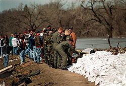
[18] Residents, local university students, and Grand Forks Air Force base personnel placed about 3.5 million sandbags at various points around the river.
[19][20] On April 16, at a public meeting, Grand Forks mayor Pat Owens recommended that residents voluntarily evacuate the city.
[21] The next day, about 500 airmen and women from Grand Forks Air Force Base were assigned to assisting with monitoring the dikes around the river.
[22] The Red River crested in Fargo at 39.5 feet (12.0 m) on April 17,[23] but dike-building efforts were able to prevent the water from flooding into a majority of the city.
Some residents of Grand Forks criticized the National Weather Service for its incorrect prediction of the river level, as it had prevented them from securing their possessions from their homes.
The most familiar footage is possibly of the fire that started on April 19 in downtown Grand Forks, surrounded by floodwaters, where eleven buildings and sixty apartments were destroyed.
[41] Additionally, their tankers were unable to reach the buildings due to the height of the floodwater and the water pressure from the hoses and fire hydrants was too weak to extinguish the flames.
[43] Also, two aircraft rescue and firefighting trucks from the Grand Forks International Airport were brought in to fight the fire because their engines were higher up off the ground, and thus did not get clogged by the flood waters.
[45] The national attention of both flood and fire reached Joan Kroc, the McDonald's heiress, who anonymously (her anonymity was later revealed to the public by the Grand Forks Herald[46]) donated $15,000,000 to be divided into $2,000 portions for each damaged household (though the amount some homeowners received was less due to the huge number of devastated homes; in all 7,500 households received funds).
[46] In November 1997, North Dakota Governor Ed Schafer reported that victims had been assisted by 50,000 relief agency volunteers who had served more than 2 million meals.
He then visited the thousands of refugees at the nearby Grand Forks Air Force Base and commented on the community's spirit, stating "Water cannot wash that away.
[50] In June, Canadian Prime Minister Jean Chrétien and President Clinton appointed the International Red River Basin Task Force containing members of both countries.
"[55] Grand Forks received $171 million from the federal program, Community Development Block Grants, which was used for 198 projects within the city.
"[57] Earl Pomeroy told the Grand Forks Herald that "the inability to get realistic flood numbers certainly hindered the communities' ability to prepare.
"[25] Anger over the predictions was most famously expressed by a local resident's devastated home having the words "49 feet my ass" smeared on the exterior.
The president of the East Grand Forks planning-and-zoning commission commented on the idea of development, "The river had been our friend for all these years.
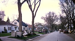
"[64] What were once entire neighborhoods, including Lincoln Drive, are now covered by grass and trees, part of an extensive area of parkland called the Greater Grand Forks Greenway.
The City of EGF hired Ernst & Young to lead the development efforts soon after the flood and David Bentley led a team to refurbish damaged facilities as quickly as possible.
[69] However, the Red River did not go near the level of the 1997 flood and only caused minor damage, primarily in rural areas, including water over roads and bridges.
[23] For Greater Grand Forks, the system of levees and new "invisible floodwalls" was completed in 2007, having cost several hundred million USD.
The areas bordering both sides of the rivers has been converted into a giant park called the Greater Grand Forks Greenway.
'"[34] Grand Forks leaders met with Biloxi city officials, and sent a list of contacts and a 24-page booklet that detailed how to coordinate volunteer agencies and how to interact with FEMA.
[70] One Biloxi city official stated that Grand Forks had "just helped us to understand what we were looking at, and gave us some direction to go in, which was really needed, with the rebuilding and the recovering.
[71] East Grand Forks mayor Lynn Stauss stated "We like to call ourselves the poster child of flood recovery because we think we showed how different governments working together could make it happen.