2004 Hallam tornado
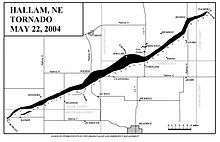
The Hallam tornado formed west and northwest of Daykin at 7:30 pm CDT at an F1 intensity on the Fujita Scale.
The main storm turned and traveled east-northeast from Daykin to a point south-southeast of Western and then to about 2 miles (3.2 km) north of Swanton.
The tornado remained confined within the F0-F1 range until it hit southern Wilber, where it intensified to F2 strength and blew roofs off of structures.
The tornado continued east-northeast, grazing the east side of Wilber as it moved towards Clatonia.
After passing just northwest of Clatonia, the tornado became violent and moved through Hallam at 8:35 pm CDT, where damage reached high-end F4 in intensity.
The tornado then reached F4 intensity again as it continued northeast to Holland before weakening again as it passed north-northwest of Panama, where mostly F1 and F2 damage was observed.