2010 Canterbury earthquake
[13][6] Mass fatalities were avoided partly due to there being few houses of unreinforced construction, although this was also aided by the quake occurring during the early hours of the morning when most people were off the street.
[23] In the first eighty years of European settlement in Christchurch (1850–1930), four earthquakes caused significant damage, the last of these centred at Motunau on the North Canterbury coast in 1922.
The study also highlighted the dangers of soil liquefaction of the alluvial sediments underlying the city, and the likelihood of significant damage to water, sewer and power supply services.
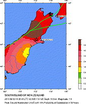
[27] The main quake occurred as a result of strike-slip faulting within the crust of the Pacific plate, near the eastern foothills of the Southern Alps at the western edge of the Canterbury Plains.
[28] The earthquake epicentre was located about 80–90 km (50–56 mi) to the south and east of the current surface expression of the Australia–Pacific plate boundary through the island (the Alpine and Hope Faults).
[31][32][33][34] Notable aftershocks, in chronological order, include: The Earthquake Commission has published two Geotechnical Land Damage Assessment & Reinstatement Report[s].
[55] The September 2010 earthquake caused two Christchurch residents to be seriously injured, one by a falling chimney and a second by flying glass, and led to many with less serious injuries.
[6] In 2020 it was suggested in the journal Earthquake Spectra that someone died after being thrown off the toilet, although Coronial Services is unable to find the coroner's report for that death.
Total Earthquake Commission (EQC), private insurance and individual costs were estimated to reach as high as NZ$4 billion according to the New Zealand Treasury.
[67] The boil water notice for Christchurch and Banks Peninsula was lifted late on 8 September 2010, after more than 500 tests conducted over three days found no contamination.
[69] All schools and early childhood centres in Christchurch City, Selwyn and Waimakariri Districts were ordered shut until Monday 13 September for health and safety assessments.
[76] This was at least in part due to outlying birthing centres being closed,[77] pending structural checks, forcing more mothers to deliver at hospitals than was generally the case.
[91] By the afternoon of Monday 6 September, the entire South Island rail network had reopened with the exception of the Main North Line between Rangiora and Addington.
[89] Major bridges on state highways and the Lyttelton road tunnel were inspected by the NZ Transport Agency, and found to be in structurally sound condition.
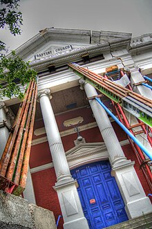
[94] The quake caused damage to historic buildings in Lyttelton, Christchurch's port town, including cracks in a church and the destruction of parts of a hotel.
It was the tallest commercial building in Christchurch when it was built in 1905–06 for the New Zealand Express Company, and blended 1890s Chicago Skyscraper style with English Edwardian architecture.
[107] The port town of Lyttelton's most notable building, the 1876 Timeball station, was also affected by the earthquake, though strengthening work completed in 2005 may have saved it from further damage.
[110] Many of Christchurch's major landmarks survived intact, including the Canterbury Provincial Council Buildings, the Anglican cathedral, and Christ's College.
[111] The Catholic Cathedral of the Blessed Sacrament (Christchurch Basilica) also survived, although it suffered severe structural damage and also had some windows broken.
[112] Others, such as the city's International Antarctic Centre and Christchurch Art Gallery, the latter of which served as the Civil Defence Headquarters during the earthquake aftermath,[96] suffered little or no damage and were able to be used immediately.
Christchurch Arts Centre, housed in the former Canterbury College buildings, was less fortunate, with moderate damage to the Great Hall, the Clocktower, and the Observatory.
[113] Also, as many of the bookshelves in the main library were toppled, with repairs expected to take until Christmas, the university arranged electronic access to many academic publishers databases for students about to sit exams.
[118] The spire of St. Joseph's Catholic Church in Temuka was also shifted 10 centimetres (4 in) by the earthquake, leaving it precariously balanced, and the town's historic Royal Hotel was also damaged.
[127] Liquefaction risk at the Pegasus Town site was identified in 2005, so the developers spent approximately $20 million on soil compaction, and the ground there held firm during the quake.
[132] By contrast, Haiti's much lower standard codes were poorly enforced and many buildings were made of hand-made non-reinforced concrete, which is extremely vulnerable to seismic damage.
[136] Police promptly arrested a couple of opportunists who had broken into a liquor store shortly after the quake and attempted to take alcohol.
[citation needed] A state of emergency was declared for Christchurch at 10:16 am on 4 September, and the city's central business district was closed to the general public.
[21] A Royal New Zealand Air Force C-130 Hercules plane brought 42 urban search and rescue personnel and three sniffer dogs from the North Island to Christchurch the day of the quake,[137] to help check for people buried in the rubble and determine which buildings are safe to use.
[140] Queen Elizabeth II asked the Prime Minister to send her good wishes to the people affected by and helping recover from the quake.
[144] 'Welfare centres' were set up with the help of Red Cross, The Salvation Army and St. John Ambulance at Burnside High School, Linwood College and Addington Raceway, where over 244 people slept on the night after the quake.