2010 Sahel famine
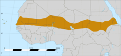
[4] The Sahel is the ecoclimatic and biogeographic zone of transition between the Sahara desert in the north of Africa and the Sudanian savannas in the south, covering an area of 3,053,200 square kilometres.
[6][7][9] In December 2009, both USAID and several NGOs predicted an increased food insecurity situation in more of the southern districts of Mali as compared to the same time the previous year.
[10] The Western donor nations once theorised that the drought in the Sahel primarily was caused by humans over-using natural resources in the region through overgrazing, deforestation[11] and poor land management.
In the early 2000s, after the phenomenon of global dimming was discovered, some speculatively suggested, that the drought was likely caused by air pollution generated in Eurasia and North America.
The lake is situated 281 metres (922 ft) above sea level and is diminishing over time due to lack of rain water and major rivers running into it.
The problem is also highlighted by the discovery of fossil pollens indicating that, in ancient times, the shores of Lake Chad supported a well-watered savanna, which contributed to a lesser level of aridity in the Sahel area.
The copious amount of water from the Ubangi would revitalise the dying Lake Chad and provide livelihood in fishing and enhanced agriculture to tens of millions of central Africans and Sahelians.
[47] Many of the world's countries, including many in Sub-saharan Africa, the Middle East and Southeast Asia, have seen a sharp rise in population since the end of the Cold War.
[68] Many NGOs and charities have begun to restrict the areas covered by their aid work in Niger, Chad, and Sudan due to the ever-present risk of bandits and kidnappers.
[98] The UN, NGOs, charities and the Sudanese government reported that food security was a major concern in South Sudan and would stay at risk until the rainy season in September.
[100] On 1 May 2010, the West African nation of Chad was on the verge of a nationwide famine as drought, armed conflict, and an influx of Darfur refugees all contributed to a chronic food shortage that now affects 2,000,000 people (20% of the country's total population).
[9] Afrol News reported on 25 May that about 2,000,000 Chadians were at risk of having a famine occur in their regions after the combined effects of 2 years of drought and pestilence had ruined their harvest yet again.
Both local critics, NGOs and overseas donor nations all wondered where the money had come from and thought it would have been better spent on buying food and irrigation equipment.
Niger, Chad, the eastern parts of Mali and northern Cameroon have also been badly affected by the failed rains and scorching heat, according to the UN World Food Programme.
Starving families were reported as either have travelled more than 1,000 kilometres (600 mi) to reach the capital Niamey to find work and/or beg for food, while others have crossed the border in Nigeria.
[110] On 7 June the Malian Government's Early Warning System released an estimate that 258,000 people were suffering from malnutrition in the towns of Gao and Kidal in April.
[114] On 9 June, various groups of hydrologists, geologists and scientists in the Sahara desert used magnetic imaging technology when looking for aquifer sites for drilling water wells in Eastern Chad.
In recent years, roughly 300,000 refugees have arrived from both the war-torn Sudan and ailing Central African Republic, thus straining the already limited water supplies.
Both Algeria, Burkina Faso, Mauritania, Morocco, Mozambique, Niger have shown a major interest in the further development of this resource lead local industry.
[115][116][117] On 11 June 2010, the UN's World Food Organisation, Oxfam and MSF all warned of an impending famine in Mali, Mauritania, Burkina Faso, Niger and northern Nigeria.
[127] On 6 July, the Methodist Relief and Development Fund (MRDF) aid experts said that more than 1,500,000 Nigerians were at risk of famine due to a month-long heat wave that was hovering over Niger, Mali, Mauritania and Morocco.
[128] The heat wave that left Morocco for the Iberian Peninsula on 11 July was attributed to the regional hot air currents that depart from the Sahara desert in Northern Africa at about 1,000 meters in altitude.
[132] Sudan witnessed minor food rioting in Southern Kordofan, Blue Nile, and Abyei as profiteering locals and merchants and Ugandan exporters took advantage of the shortages in order to heavily mark up their selling prices.
[139] Human Rights Watch (HRW) said the Sudanese Nuer–Dinka war was hampering relief efforts and damaging agricultural output in parts of South Sudan.
[142] 14 August saw protests across Sénégal over concerns relating to the ruling party's poor governance in the face of recent floods, storms and power cuts across the country, along with the current heavy drought in Senegal's Sahel region.
[68] Many NGOs and charities had started to restrict the areas covered by their aid work in Niger, Chad and Sudan, due to the ever-present risk of bandits and kidnapers.
[146] He was quoted to have said in the interview that: But, today, where there is suffering without hope, we can prevent children dying painful, avoidable deaths[146]On 31 August Sudan's army reported that 3 Russian helicopter crew members had been abducted by gunmen in Nyala, capital of South Darfur, just hours after Samaritan's Purse aid worker Flavia Wagner who had been kidnapped 18 May was set free.
[148] 8 September saw a Chinese CGC Overseas Construction Co. Ltd. oil worker kidnapped in Bahaï, Chad and took him to Sharq al-Teyna, in Sudan's Darfur region.
On 9 June 2010 various groups of hydrologists, geologists and scientists in the Sahara desert used magnetic imaging techniques when looking for sites in aquifers for drilling water wells in Eastern Chad.
The signatory countries were from the Permanent Interstate Committee for drought control in the Sahel (CILLS) and West Africa Club (SWAC), and the Gambia, which was also hosting the event.