Red Sea
A line joining Husn Murad (12°40′N 43°30′E / 12.667°N 43.500°E / 12.667; 43.500) and Ras Siyyan (12°29′N 43°20′E / 12.483°N 43.333°E / 12.483; 43.333).Exclusive economic zones in Red Sea:[4] Note: Hala'ib Triangle disputed between Sudan and Egypt and calculated for both.
As well as Mare Rubrum in Latin (alternatively Sinus Arabicus, literally "Arabian Gulf"), the Romans called it Pontus Herculis (Sea of Hercules).
[5] Other designations include the Arabic: البحر الأحمر, romanized: Al-Baḥr Al-Aḥmar (alternatively بحر القلزم Baḥr Al-Qulzum, literally "the Sea of Clysma"), the Coptic ⲫⲓⲟⲙ ̀ⲛϣⲁⲣⲓ Phiom ̀nšari, Syriac ܝܡܐ ܣܘܡܩܐ Yammāʾ summāqā, Somali Badda cas and Tigrinya Qeyyiḥ bāḥrī (ቀይሕ ባሕሪ).
The direct rendition of the Greek Erythra thalassa in Latin as Mare Erythraeum refers to the north-western part of the Indian Ocean, and also to a region on Mars.
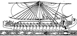
The earliest known exploration of the Red Sea was conducted by ancient Egyptians, as they attempted to establish commercial routes to Punt.
Rabbi Saadia Gaon (882‒942), in his Judeo-Arabic translation of the Pentateuch, identifies the crossing place of the Red Sea as Baḥar al-Qulzum, meaning the Gulf of Suez.
[14] In the 6th century BC, Darius the Great, who was a prominent ruler of the Achaemenid Empire in Persia, undertook significant efforts to improve and extend navigation in the Red Sea.
[15] In addition to the maritime explorations, during the reign of Darius the Great, a canal was constructed linking the Nile River to the northern end of the Red Sea at Suez.
It played a pivotal role in improving trade and communication between the Nile Valley and the Red Sea, and beyond to the Indian Ocean.
Darius commemorated the completion of the canal by creating stelae (stone monuments) with inscriptions in several languages, describing the construction and its benefits.
The canal not only facilitated trade but also solidified Darius's control over Egypt and enhanced the Achaemenid Empire's economic and political power in the region.
In the late 4th century BC, Alexander the Great sent Greek naval expeditions down the Red Sea to the Indian Ocean.
Contact between Rome and China depended on the Red Sea, but the route was broken by the Aksumite Empire around the 3rd century AD.
They cruised the Red Sea inside the Bab al-Mandab, as the first fleet from Europe in modern times to have sailed these waters.
Today, in spite of patrols by the major maritime fleets in the waters of the Red Sea, the Suez Canal has never recovered its supremacy over the Cape route, which is believed to be less vulnerable to piracy.
[citation needed] Iranian-backed Yemini Houthis have attacked Western ships, including warships, next to the Bab al-Mandeb during the Israel–Hamas war.
These physical factors reduce the effect of high salinity caused by evaporation in the north and relatively hot water in the south.
The average surface water temperature of the Red Sea during the summer is about 26 °C (79 °F) in the north and 30 °C (86 °F) in the south, with only about 2 °C (3.6 °F) variation during the winter months.
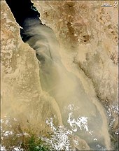
Wind-generated current measurement is therefore important in order to determine the sediment dispersal pattern and its role in the erosion and accretion of the coastal rock exposure and the submerged coral beds.
The sea is still widening (in 2005, following a three-week period of tectonic activity it had grown by 8 m [26 ft]),[36] and it is considered that it will become an ocean in time (as proposed in the model of John Tuzo Wilson).
Lake Asal in Djibouti is eligible as an experimental site to study the evolution of the deep hot brines of the Red Sea.
[38][failed verification] Sometime during the Tertiary period, the Bab el Mandeb closed and the Red Sea evaporated to an empty hot dry salt-floored sink.
[49] Since the opening of the Suez Canal in November 1869, over a thousand marine species from the Red Sea—from plankton, seaweeds, invertebrates to fishes—have migrated northward and settled in the Mediterranean Sea.
The resulting change in biodiversity, without precedent in human memory, is currently accelerating, in particular for fishes according to surveys engaged by the Mediterranean Science Commission.
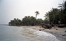
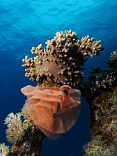
The reefs form platforms and sometimes lagoons along the coast and occasional other features such as cylinders (such as the Blue Hole (Red Sea) at Dahab).
Furthermore, the deep Red Sea brine pools have been extensively studied with regard to their microbial life, characterized by its diversity and adaptation to extreme environments.
The rules and regulations governing this area protect local marine life, which has become a major draw for diving enthusiasts who should be aware that although most Red Sea species are innocuous, a few are hazardous to humans.
There are at least 18 desalination plants along the Red Sea coast of Saudi Arabia which discharge warm brine and treatment chemicals (chlorine and anti-scalants) that bleach and kill corals and cause diseases in the fish.
The popular tourist beach of Sharm el-Sheikh was closed to all swimming in December 2010 due to several serious shark attacks, including a fatality.
The Red Sea Project is building highest quality accommodation and a wide range of facilities on the coast line in Saudi Arabia.