2014 Pilger, Nebraska, tornado family
The tornadoes impacted areas east of Norfolk, including the village of Pilger, which sustained major damage, as well as farmsteads near Stanton, Wisner, and Wakefield.
This tornado traveled for approximately 12 miles, causing extensive damage to several farmsteads and sweeping away a few farmhouses before lifting north of Dewey.
The final violent tornado from the supercell swept away three farmhouses and inflicted significant damage on multiple other farmsteads before dissipating north of Wakefield.
[5] Beginning at around 0800 UTC, however, favorable conditions for severe weather, particularly for large hail, began to build across central Nebraska.
Moisture from the Gulf of Mexico began to make its way into southern Nebraska and over Kansas, raising dew points over the region.
[8] This was followed shortly after by the day's first severe thunderstorm watch, issued for primarily eastern Nebraska in response to a developing line of supercells.
[11] At 1613 UTC, the SPC issued the first of three public severe weather outlooks for the day, covering a region centered on Sioux City, Iowa.
It moved northeastward over open terrain with few damage indicators, although an area of snapped trees near 561st Ave received a high-end EF1 rating.
The tornado then weakened to EF1 strength, continuing to snap trees and power poles before rapidly intensifying to a much stronger high-end EF3 intensity as it struck a farmstead along 563rd 1/2 Avenue.
[15][16] The tornado then weakened to EF2 intensity as it struck another farmstead, causing major roof damage to the farmhouse, partial wall collapse, and the destruction of outbuildings.
The tornado continued traveling northeastward, snapping multiple softwood trees, and became violent once more as it crossed 842nd Rd on Payne Creek.
[16] The tornado traveled 12.21 miles (19.65 km), lasted 29 minutes, caused no injuries or fatalities, inflicted $2.25 million (2014 USD) in damages, and had a maximum wind speed of 170 mph (274 km/h).
At 4:00 p.m. CDT, the tornado touched down 5.5 miles (8.9 km) southwest of Pilger on 570 Ave near Cedar Creek, causing minor damage to trees.
The tornado continued northeast, regaining EF1 strength on 572 Ave, where it snapped trees and caused minor roof damage to an outbuilding.
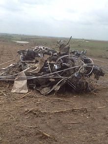
Along the street, a well-constructed home at the intersection of E 2nd St and N Monroe was completely swept off its foundation, receiving the highest damage rating in the town at 189 mph (304 km/h).
[20][21][22] St. John Lutheran Church was leveled and partially swept away at near high-end EF4 intensity, leaving only the bell tower standing.
The main tornado struck a farmstead along Highway 12 at mid-range EF2 intensity, ripping away a large part of the roof and leveling an outbuilding across the road.
The tornado then slightly strengthened to high-end EF2 intensity, causing severe damage to the exterior walls of a home before abruptly dissipating.
As it passed near St. Paul's Lutheran Cemetery, the tornado entered Wayne County, causing additional tree damage.
It then rapidly intensified to high-end EF4 strength, obliterating a farmstead along 581st Ave. A well-built farmhouse on this property was swept clean off its foundation with estimated wind speeds of 191 mph (313 km/h).
Further north, the tornado struck another farmstead, leveling an outbuilding, causing significant roof loss to a metal building, and denting a grain silo.
Several farmhouses east of Wakefield suffered significant roof damage before the tornado entered Dixon County.
[24] Matthew 25: Ministries went to the village of Pilger and the surrounding areas to help with tornado relief donating products like tarps, blankets, etc.
[37] American musician, Bret Michaels and his band drove to the village of Pilger on June 23, to assist with the clean up effort and help rebuild.
[40] Governor of Nebraska, Dave Heineman, declared a state of emergency for Pilger and the areas around the village and the National Guard came in to assist with emergency respondents, a shelter was opened up in Wisner-Pilger High School in Wisner, Governor Dave Heineman would later tour the village two days after the tornado.
[46] Multiple damaged structures were bulldozed and construction projects were placed to rebuild; the bank that was destroyed in Pilger announced that it will rebuilt.
Their research focused on how structural defects can make infrastructure more susceptible to the intense wind speeds of high-end tornadoes.
[49] In 2022, researchers Lanny Dean, David Moran, and Randy Hicks published a study based on a scientific field campaign.
The footage revealed detailed insights into the tornado’s core wind field and uncovered previously undocumented phenomena, including the presence of multiple sub-vortices.
[50][51] On January 23, 2025, Anthony W. Lyza with the National Severe Storms Laboratory along with Harold E. Brooks and Makenzie J. Kroca with the University of Oklahoma’s School of Meteorology published a paper to the American Meteorological Society, where they stated the main Pilger twin tornado was an "EF5 candidate", specifically at the well-built farm house which received a rating of EF4 with winds of 191 miles per hour (307 km/h).


EF1 86–110 mph
EF2 111–135 mph
EF3 136–165 mph
EF4 166–190 mph
⎯ Center of the tornado

EF1 86–110 mph
EF2 111–135 mph
EF3 136–165 mph
EF4 166–190 mph
⎯ Center of the tornado