2016 Ecuador earthquake
The 2016 Ecuador earthquake occurred on April 16 at 18:58:37 ECT with a moment magnitude of 7.8 and a maximum Mercalli intensity of VIII (Severe).
[8][9][10] President Rafael Correa declared a state of emergency; 13,500 military personnel and police officers were dispatched for recovery operations.
[16] According to Mayor Gabriel Alcivar, much of the town of Pedernales, about 35 km to the south-southwest of the earthquake's epicenter, was leveled.
[19] The earthquake was presaged by a magnitude 4.8 foreshock eleven minutes before the main quake struck,[20] and followed by over fifty-five aftershocks in the first twenty-four hours.
The number of injuries reported by media also remained below the ultimate count and below the correct estimate within 30 minutes by QLARM as seen in the next figure.
The USGS shake map for this event shown on this page depicts the extent of the rupture area as a rectangle.
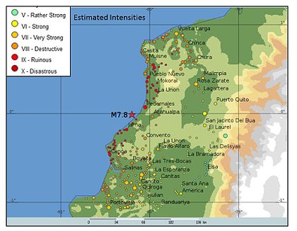
In that case, maps of the intensity of shaking expected in each settlement may be calculated as in the figure below at the left for the 2016 Ecuador earthquake.
In Colombia, near the city of Cali, one miner died as a result of the earthquake, becoming the only reported death outside of Ecuador.
[34] In response to the earthquake, a state of emergency was declared throughout the country and the national guard was mobilized to assist in rescue and relief efforts.
On April 17 the International Charter on Space and Major Disasters was activated by UNITAR/UNOSAT on behalf of UN OCHA, thus providing for the charitable and humanitarian re-tasking of satellite assets.
[36] José Joaquín de Olmedo International Airport in Guayaquil was also closed due to communication issues.
[38] Days after the earthquake, the country experienced difficulties distributing food and water to those in need, including the over 26 thousand survivors relocated to shelters.
[40] Gómez Tapias, Jorge; Montes Ramírez, Nohora E.; Almanza Meléndez, María F.; Alcárcel Gutiérrez, Fernando A.; Madrid Montoya, César A.; Diederix, Hans (2015).