3D fold evolution
Three-dimensional fold growth can be observed in areas like the Zagros Mountains in Iraq and Iran[6] as well as Wheeler Ridge in California, United States.
[8] Sheath folds form in areas where rocks react differently to simple shear, due to variations in competence across layers.
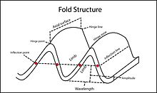
[9] Under force, rock strata buckle occurs by one of two kinematic processes, either by hinge migration or by limb rotation.
[1][10][13] A knickpoint is a morphological term for a section of a present or abandoned river valley that shows an abrupt change in slope, and can be attributed to differential erosion or structural deformation.
Apart from stress parameters, contrast of competency across strata and variation of displacement along the decollement are the main factors contributing to fold geometry and three dimensional growth pattern.
[3] Shortening stress is usually at a high angle to the strata and is concentrated along the slipping plane and in the hanging wall of the thrust fault.
[26] When compared to detachment folds, contrasting competency across strata is not as pronounced[23] and the tectonic environments that they are found in are often more diverse.
[27] An exemplar structure of this kind can be found in Mississippi Fan fold belt in Gulf of Mexico.
[32] Alternatively, geomorphological evidences, especially drainage features, can be used to determine the lateral propagation direction of fold growth.
[34][35] Older sections of a fold experience more erosion and therefore have a different soil profile compared to their younger counterparts.
[7] Nevertheless, this criterion of comparison is based on an assumption that time is the only significant factor contributing to the differences of soil profiles across different parts of a fold, and excludes other factors for variation such as parent materials of soil, climate, vegetation and initial topography.
It continues to flow until the rock is further uplifted and the river no longer has enough erosive power to cut through it, leading to the second scenario.
Second scenario: the stream does not have enough erosive power to cut through the rocks, so it deflected to flow along the boundary of the uplifted block as aforementioned.
From here, the river either flows along the boundary of the fold and bends around the fold tip, or it may cut through the rocks at some points despite the block, due to either, acquisition of enough stream power through stream capture of small tributaries along its flow, or the presence of a particularly weak spot in the rock.
[33] In a topographic profile along fold crest, wind gaps appears as deep, narrow v-shaped valley.
[33] As former deflected streams, some of the wind gaps may show curvature that convex towards the direction of lateral fold growth.
[7] Structural deformation in the area has been active since late Pleistocene, resulting in significant three-dimensional fold growth.
Thereby it supports a west-to-east fold growth direction Second, the main flowing river channels show a curvature that bends towards the east-southeast.
The curvature seems to a result of gradual uplift of rocks towards the east-southeast and shows resemblance to the patterns of deflected streams during lateral fold growth.
[7] Third, the abandonment of old river channels (formation of wind gap) can be seen in a topographic profile across ridge crest.
[4][39][40][41] Conversely, the faults that are located in stress shadow are relaxed and have a lower frequency of rupture and growth rates.
[4] On the other hand, the faults that orient in the stress shadow will decrease in growth rates and even become inactive in the long term.


Brown line: fold hinge line;
Red arrow: direction of lateral fold growth.

Brown line: fold hinge line;
Red arrow: direction of lateral fold growth.

Brown line: fold hinge line;
Brown arrow: plunging direction of fold;
Red arrow: direction of lateral fold growth;
Amid: relative height of the horizontal middle of the area;
D: perpendicular distance between hinge lines of the approaching folds.