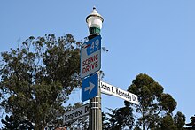
49-Mile Scenic Drive
It was created in 1938 by the San Francisco Down Town Association to showcase the city's major attractions and natural beauty during the 1939 Golden Gate International Exposition.
[10] At Jefferson Street, the route proceeds alongside the waterfront—passing Aquatic Park and the San Francisco Maritime Museum with several quick turns heading into the Marina District near Fort Mason.
The route detours through the Marina Green parking lot and takes a path of residential streets to the Palace of Fine Arts, the most prominent remaining structure from the 1915 Panama–Pacific International Exposition.
Passing above Crissy Field and Fort Point, under the U.S. Highway 101 (US 101) approach to the Golden Gate Bridge, and above Baker Beach, the route exits the Presidio into Sea Cliff.
Turning westward onto Geary Boulevard, drivers proceed several blocks and continue onto Point Lobos Avenue, soon reaching the Sutro Baths and Cliff House.
[14] At 15.2 miles (24.5 km),[3] the route proceeds due south along the city's Pacific coast on Great Highway, passing Ocean Beach, the edge of Golden Gate Park, the San Francisco Zoo, and skirting Lake Merced before returning north on Lake Merced Boulevard past San Francisco State University and continuing through the Sunset District along Sunset Boulevard.
[17] Briefly skirting the Haight-Ashbury and Cole Valley neighborhoods, the route ascends Parnassus Street and passes the University of California, San Francisco's main campus.
Winding its way down the hill, the route takes drivers past the Randall Museum before descending east along 14th Street into San Francisco's prominent gay neighborhood, The Castro.
In July 1938, President Franklin D. Roosevelt was given a vehicular tour of the city, including its two bridges, with Senator William Gibbs McAdoo and Mayor Angelo Joseph Rossi before speaking at the Treasure Island fairgrounds, site of the Golden Gate International Exposition of 1939–40.
[23] Later that year, the San Francisco Down Town Association devised a route from behind City Hall to Treasure Island that was originally titled the "50-Mile Scenic Drive", marking the way with blue and gold triangular signs.
[1] The name was changed shortly thereafter—probably with marketing intentions—to reflect San Francisco's approximate area (46.9 square miles (121 km2)) and reference the California Gold Rush of 1849, from which the term "forty-niner" originates.
On September 14, 1938, the 49-Mile Scenic Drive was officially opened by Douglas Corrigan, who had achieved fame (and his nickname, "Wrong Way") earlier in 1938 for claiming to fly from New York City to Los Angeles but ending up in Dublin.
[5] In 1947, the drive reopened with an expanded southeastern segment, which now continued south past Mission San Francisco de Asís to Excelsior, McLaren Park, and Visitacion Valley before returning via the Bayshore Freeway and Bryant Street to The Embarcadero.
A longer route through Golden Gate Park now included a circle of Stow Lake from the north, and the southeastern loop to Visitacion Valley was truncated and replaced by a turn on Army Street (Cesar Chavez).