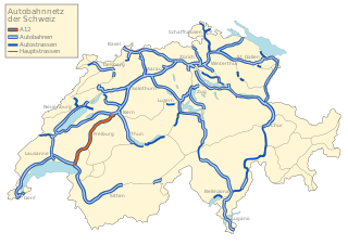
A12 motorway (Switzerland)
During the first 5.5 kilometres (3.4 mi), the highway rises along the eastern flank of the Veveyse up to 820 metres (2,690 ft) above sea level and forms a sharp S-curve.
The culminating point is located, at an altitude of 866 metres (2,841 ft) above sea level, at Weiler Prayoud northeast of Chatel-Saint-Denis.
At a length of 15 kilometres (9.3 mi), the A12 now runs at an altitude of about 800 metres (2,600 ft) above sea level, before it reaches the Gruyère region and the basin of Bulle.
Thereafter, the A12 runs through the relatively densely populated and industrial and commercial buildings lined Wangental valley, to the western border of the city of Bern.
Following is the Southern Bypass of the district Bümpliz, with an almost 1-kilometre-long (0.62 mi) bridge crossing the plateau, before the highway ends at the junction Weyermannshaus into the A1.
As a result, developed the line from Bern via the A12 and the A9 for Lausanne on the A1 for approximately 20 years to the main transit route between Zürich and Geneva.
However, the A12, during the winter, was always vulnerable to ice and snow-covered roadways because of the steep gradients and long sections at elevations above 700 metres (2,300 ft).