A1 in London
[3] The roads along which the A1 route travels are the shared responsibility of the local boroughs, the Greater London Authority, and the British Government via the Department for Transport.
The A1 is the latest in a series of routes north from London to York and beyond, and was formed in 1921 by the Ministry of Transport as part of the Great Britain road numbering scheme.
[8] By the 12th century, because of flooding and damage by traffic on Ermine Street, an alternative route out of London was found through Islington and Muswell Hill, and this was the origin of the Great North Road that would become the A1.
[16] Responsibility for the roads along which the A1 route travels are shared by the individual local boroughs, the Greater London Authority (GLA), and the British Government.
[3] Due to the problems associated with two different and opposing bodies having responsibility for London's roads, the government were keen to take control of the major routes, and made plans in 1983 for the Department of Transport to take over 70 miles of road, including significant parts of the A1; when the GLC was abolished in 1986, the Department of Transport took over direct control of the 70 miles of major routes, plus had a significant influence on another 300.
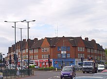
[27] The route enters the London Borough of Islington at Goswell Road becoming a single carriageway running north from the border of the City to Angel through a mix of offices and urban housing.
[30] The street was reported in 1720 to be "meanly built and inhabited", containing numerous inns and brothels, and it largely remained a slum area until the rebuilding that took place after the Second World War – in particular the residential development outward from the Barbican and Golden Lane estates since 1980, replacing warehouses with flats.
[27] At the northern end of Goswell Road, the route northwards follows a one-way section to the Angel, turning right into Islington High Street.
At this time, nine inns (including the Angel, which subsequently gave its name to the area), as well as housing and a public pond were shown lining the street.
[34] Livestock herded along the Great North Road for Smithfield Market, would – when passing through what was mainly fields and farmland – pause at lairs built between Upper Street and Liverpool Road by an enterprising farmer, Richard Laycock;[35] Laycock's lairs would be used in 1861 for the site of the Royal Agricultural Hall,[36] and a number of pubs and shops existed along the street to serve farmers and travellers headed for Smithfield.
The construction of the interchange left a few buildings isolated in the centre of the roundabout, including the Archway Tavern, which appears on the cover of the Kinks' 1971 album Muswell Hillbillies.
By 1808 this was proving unsuitable for increasingly heavy traffic, and a road, crossing the hill through a tunnel at a shallower gradient, was proposed by a mining engineer, Robert Vazie; a turnpike trust – the Highgate Archway Company – was set up and work started in 1810.
[49] It was the venue for the mental illness campaign group Mad Pride's inaugural vigil in 2000,[50] and was the subject of Johnny Burke's 2006 film The Bridge.
[51] When, at the end of 2010, three men in three weeks committed suicide by jumping from the bridge, a campaign was set up by local residents for better anti-suicide measures to be put in place.
[62] The road is named after Sir Fenton Aylmer,[63] who received the Victoria Cross for his part in the assault on Nilt Fort on 2 December 1891.
[64] After crossing The Bishops Avenue, the A1 becomes Lyttelton Road, which was laid out in 1931 as part of the residential development of the area,[65] and runs east–west along the northern foot of Highgate Hill between Hampstead Garden Suburb and East Finchley.
After passing playing fields to the south, the A1 briefly becomes Market Place, a former street market that has evolved into a short stretch of shops, then becomes Falloden Way – built between 1914 and 1924 as part of a programme of planned extensions to Hampstead Garden Suburb,[67] and runs on an embankment due to a dip in the ground caused by Mutton Brook, a tributary of the River Brent, which runs parallel to the road for its entire length, mostly along the south side.
The junction had an £8 million upgrade completed in January 2012,[70] which included Britain's first "hands-free" pedestrian crossing to allow Orthodox Jews to reach the nearby Finchley Synagogue, one of Europe's largest,[71] without operating machinery on the Sabbath.
After the Henlys Corner interchange, the routes diverge, with the A406 going south to Brent Cross, while the A1 turns north-west as Great North Way through the leafy suburbs of Mill Hill and Hendon.
Great North Way, built in 1926, joins Watford Way carrying the A41, completed in 1927, at Fiveways Corner, and in 1970 a junction with the M1 motorway was created.
[76][77] The northbound carriageway passes the entrance to Scratchwood, an area of ancient forest which is now a local nature reserve, then crosses the A411 from Watford to Barnet at the Stirling Corner roundabout.
A 0.6 miles (0.97 km) proposed link road at this roundabout, estimated at £22.8m in 1987, would have provided access to the M1,[78][79] but the plans were subsequently abandoned.