Addis Ababa
[10] The founding history of Addis Ababa dates back to the late 19th century by Menelik II, Negus of Shewa, in 1886 after finding Mount Entoto unpleasant two years prior.
[11] Addis Ababa saw a wide-scale economic boom in 1926 and 1927, and an increase in the number of buildings owned by the middle class, including stone houses filled with imported European furniture.
[19] A study based on DNA evidence from almost 1,000 people around the world suggests that early humans first traveled out of Africa via a place close to Addis Ababa, spreading from the region to the rest of the planet some time around 100,000 years ago.
[21] Mount Entoto, a high tableland to the north of current Addis Ababa, is one of a handful of sites put forward as a possible location for a medieval imperial capital known as Barara.
[22] The city was depicted standing between Mount Zuqualla and Menegasha on a map drawn by the Italian cartographer Fra Mauro in around 1450, and it was razed and plundered by Ahmed Gragn while the imperial army was trapped on the south of the Awash River in 1529, an event witnessed and documented two years later by the Yemeni writer Arab-Faqih.
[11] Menelik, initially the King of the Shewa province, had found Mount Entoto a useful base for military operations in the south of his realm, and in 1879 he visited the reputed ruins of the medieval town and the unfinished rock church.
Other nobility and their staff and households settled in the vicinity, and Menelik expanded his wife's house to become the Imperial Palace in 1887 which remains the seat of government in Addis Ababa today.
Early residential dwelling was typically made of circular huts; walls were constructed with mud (Amharic: ጭቃ, cheka) and straw plastered on a wooden frame and thatched roofs.
According to Richard Pankhurst (1968), the city's accelerated population growth was due to factors of provisional governors and their troops, the 1892 famine, and eventually the Battle of Adwa.
[30] The Italian ambition regarding Addis Ababa was to create a beautified colonial capital city along with a new master plan launched by seven architects such as Marcello Piacentini, Alessandro Bianchi, Enrico Del Debbio, Giuseppe Vaccaro, Le Corbusier, Ignazio Guidi and Cesare Valle.
His two counterparts, Guildi and Valle prepared the master plan in summer 1936 likely emphasizing fascist ideology with monumental structure and no native Ethiopian participation in designing sector.
Two parallel axis were drawn in European character connecting Arada/Giyorgis with the railway station to the south end five kilometers long and varied width spanning from 40 to 90 meters.
In 1946, Haile Selassie invited famous British master planner Sir Patrick Abercrombie with goals of modelling and beautifying the city to become the capital for Africa.
By this organizing model, Abercrombie launched the master plan with neighborhood units surrounded by green parkways, and he was encouraged to draw ring roads characterized by radial shapes to channel traffic pathway from the central area.
The bureaucratic rule of the Derg postponed the master plan for eight years until 1994, which caused failure of basic issues in public service and unplanned development.
[38] This escalated to full blown strikes and street protests on 12 November 2015 by university students in Ginchi town, located 80 km southwest of Addis Ababa city, encircled by Oromia Region.
[45][46][47][48][49] In October 2022, the government launched Sheger City, an urban development model that contains 12 sub-cities, 36 districts and 40 rural kebeles with its seat located in Saris area in Addis Ababa.
This period coincides with summer, but the temperatures are much lower than at other times of year because of the frequent rain and hail and the abundance of cloud cover and fewer hours of sunshine.
Launched in 2004, the program is the result of a strategic partnership between the Glocal Forum, the Quincy Jones Listen Up Foundation, and Mr Hani Masri, with the support of the World Bank, UN agencies and major companies.
In most churches, Emperor Haile Selassie employed political propagandic panel that demonstrate his imperial power, cult of personality and ultranationalist views.
The church, located at the northern end of Churchill Road—is unique octagonal architecture—has a museum of imperial weaponry including swords and tridents and giant helmets made from the manes of lions which was used during the Italian invasion.
The church served burial of major prominent people in Ethiopia, also tombs of imperial family such as Haile Selassie and his wife Menen Asfaw, the third patriarch Abuna Tekle Haymanot and Abune Paulos.
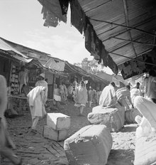
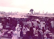
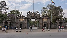
[106] Other features of the city include the large Mercato market, the Jan Meda racecourse, Bihere Tsige Recreation Centre and a railway line to Djibouti.
The African Union is now housed in a new headquarters built on the site of the demolished Akaki Prison, on land donated by Ethiopia for this purpose in the southwestern part of the city.
In the Derg era, propagandic communist pieces often conceded and several new theatres were opened until the successive government under EPRDF altered new form of cultural life with continuation of development.
The city is known for annual 10 km road event called the Great Ethiopian Run, created by athlete Haile Gebrselassie, Peter Middlebrook and Abi Masefield in late October 2000.
However Menelik faced disapprobation by general populace who adapted traditional element, though he encouraged to expand educational institution, forced parents to send their children to school.
In 2002/2003, the number of privately owned school accounted for 98, 78, 53, 41, and 67 percent of preschool, primary, secondary, technical and vocational and colleges institutions compared to survey of 1994.
The Ring Road was divided into three major phases that connect all the five main gates in and out of Addis Ababa with all other regions (Jimma, Bishoftu, Dessie, Gojjam and Ambo).
The Ethiopian Railway Corporation reached a funding agreement worth millions of dollars with the Export and Import Bank of China in September 2010 and the light rail project was completed in January 2015.