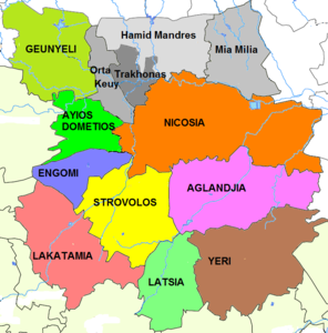
Administrative divisions of Nicosia
These units are: Ayios Andreas (former name: Tophane), Trypiotis, Nebethane, Tabakhane, Phaneromeni, Ayios Savvas, Omerie, Ayios Antonios (St. Anthony), St. John, Taht-el-kale, Chrysaliniotissa, Ayios Kassianos (Kafesli), Kaïmakli, Panayia, St Constantine & Helen, Ayioi Omoloyites, Arab Ahmet, Yeni Jami, Omorfita, Ibrahim Pasha, Mahmut Pasha, Abu Kavouk, St. Luke, Abdi Chavush, Iplik Pazar and Korkut Effendi, Ayia Sophia, Haydar Pasha, Karamanzade,[1] and Yenişehir/Neapolis (separated from Ibrahim Pasha 25 January 2010[2]).
Pallouriotissa, also annexed in 1968, was subsequently divided into the neighbourhoods of Panayia, and St Constantine & Helen.
After being declared a municipality Lakatamia was, for administrative purposes, divided into the following four parishes: Ayia Paraskevis, St. Nicholas, Ayios Mamas, Archangel-Anthoupolis.
The built up area of Yeri just touches Latsia near their mutual boundary and thus the new municipality is conurbated with Nicosia.
Previously a village authority, it now functions as a municipality[8] within the same area[9] Gönyeli is divided into the Neighbourhoods of Baraj (barrage), Çarşı, Baz and Yeni Kent (new town).
[13] Ortakeuy Village authority[14] has similarly been redefined as a neighbourhood of Nicosia Turkish Municipality.
[15] The Mia Milia Village Council of the Republic of Cyprus continues to operate in exile,[16] but the Nicosia Turkish Municipality considers it one of its neighbourhoods.
[17] The ethnically mixed Village of Trakhonas has suffered several displacements of both its Greek and Turkish Cypriot inhabitants since the 1960s and since the invasion has been heavily urbanised.
: type of local authority (Mun: municipality, Vill: village, Neigh: neighbourhood, Set: settlement).