Aerial firefighting and forestry in southern Australia
This deadly pattern continued with more major fires on Black Sunday on 14 February 1926 which saw the tally rise to sixty lives being lost and widespread damage to farms, homes and forests.
[9] In the early part of last century, there was limited road access to the extensive mountain forests, particularly in the remote and uninhabited eastern ranges of Victoria so there was a strong level of enthusiasm for aerial bushfire reconnaissance.
[11]Discussion took place between the Forests Commission Victoria (FCV) and the Air Board as early as 1926, and then over a period of years prior to 1929-30, with the view to commencing regular fire patrols using RAAF aircraft but a lack of safe landing areas proved the main obstacle.
Eventually, the first fire spotting aircraft in Victoria was deployed on 18 February 1930[12] when a RAAF Westland Wapiti from No.1 Squadron operating out of Point Cook near Melbourne flew over the nearby Dandenong Ranges.
[15] The Western Australian Forests Department went as far as purchasing four Piper PA18 light aircraft in 1978-79 and employed their own pilots to operate reconnaissance flights in conjunction with private planes.
[15] Later, the Tasmanian Forestry Commission undertook Australia's first large scale aerial forest survey in April 1930 when an area of nearly 900 square km (222,000 acres) was photographed in the north-western region by the Air Board.
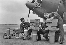
[20] Large sheets of A0 parchment, transparent overlay film, a light table, a set of Derwent coloured pencils, Rotering ink pens and a steady hand were needed for mapmaking.
The Mapper was suspended under a Cessna 182 with all the clumsy electronic equipment mounted in the back seat of the aircraft, but the results were disappointing because overnight rain had deadened the temperature difference.
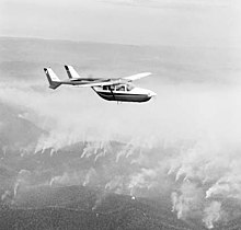
However, the operational “coming of age” of this technology occurred a year later during the 1984-85 bushfire season when an infrared linescanner was mounted in a NSCA Kingair 200C and a GAF Nomad aircraft were used to monitor the spread of major fires and the progress of back burning across North Eastern Victoria.
The geospatial revolution in bushfire mapping and navigation came of age when powerful computers and the internet converged with a number of new digital technologies including:[24] Firebombing in a military sense was developed during WW2 and designed to damage a target using incendiary devices, rather than from the blast effect of large bombs.
[28] The first trials of using aircraft to attack fires in Australia were conducted in Victoria in 1937-38 when the Forests Commission carried out tests in conjunction with Australian Paper Manufactures (APM) dropping brine solution (bitterns) in cartons.
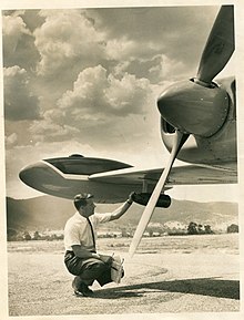
[15] Further trials were conducted by the Forests Commission just after the end of WW2 at Anglesea in Victoria beginning in November 1946 to compare the performance of RAAF P51 Mustangs, Consolidated B-24 Liberators and Avro Lincoln Bombers dropping ammonium sulphate compounds in 500 lb bombs from about 100 feet which were designed to burst on impact.
[15] On 6 February 1967 two Piper Pawnees from Benambra near Omeo, flown by Ben Buckley and Bob Lansbury, made Australia's first operational drop of fire retardant slurry on a small lightning-strike.
[35] The "proof of concept" that resulted from the firebombing at Benambra combined with new and more powerful aircraft into the late 1960s led to improved techniques for handling, mixing, storing and loading equipment for Phoschek.
[1] Innovations continued and on 3 March 1970, a Canadian de Havilland Twin Otter was trialled at Snowy Plains fitted with two 1100 litre membrane tanks which were slashed by a guillotine to discharged the load and control the drop pattern.
However, for helicopters equipped with bellytanks and use hover-fill pumps, or those with buckets on ‘short’ lines, pilots prefer to use fresh water to avoid ingesting salt into the turbine engines which are susceptible to corrosion.
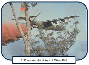
The equipment known as Modular Airborne Firefighting System (MAFFS) was trialled bombing bushfires with a slurry of an Australian made chemical fire retardant (Amgard-A11) in quantities up to 11,000 litres per drop.
[38] MAFFS could deliver a much greater volume than was possible with the smaller agricultural aircraft contracted to the Forests Commission at the time and was used effectively in the suppression of bushfires at Broadford, Bright and Orbost.
[1] The Search and Rescue Department of the Civil Aviation Authority sought the assistance of the Forests Commission in February 1972 to carry out tests at Managalore airport north of Melbourne with a Fokker Friendship F27 which led to NSW Emergency Services dropping over 3,000 heliboxes during the 1974 floods.
[1] Special containers and weighted canvas envelopes were developed by the Forests Commission to drop maps and line scanning imagery from fixed wing aircraft before live streaming of data became available.
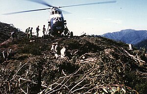
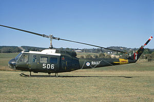
Rappelling or lowering of firefighters from a hovering helicopter was first trialled by the Forests Commission Victoria at Erica not long after WW2 in 1949 using a RAAF Sikorsky S-51 Dragonfly which was normally based at East Sale.
[1] The Forests Commission Victoria then contracted its own Bell 47G in 1964 and after some initial trials at Snowy Plains and Tallangatta established rappel operations based at Heyfield with a two-man crew.
It was revisited again in 1991 to enable specialist crews to deploy from a maximum height of 1.3 m and is ideally suited where vegetation or terrain prevented a helicopter from conducting a full skid landing such as rocky areas in the Grampians and the desert scrub country in Western Victoria.
[1] Australia is well known for being one of the driest continents on earth, which is often beset with prolonged droughts, so any opportunity to increase rainfall was seen of great national significance and many innovative and sometimes bizarre ideas were put forward.
[49] Over the next 18 years, the RAAF and CSIRO Division of Cloud Physics collaborated with state forest, fire and agricultural agencies testing different aircraft, chemicals, techniques, and delivery systems.
[15] The Prime Minister Malcolm Fraser then directed the RAAF to supply a CH47 Chinook to support remote firefighting operations on Mount Buffalo transporting large quantities of personnel and cargo onto the plateau.
[53] In NSW, an additional A$38 million was set aside in 2017 by the Rural Fire Service for two new Large Air Tankers (LAT), DC-10 and Lockheed L100, to supplement their existing aircraft fleet including two ex-Army Blackhawks.
[54] A similar situation existed in America in 2003 where the US Forest Service and Bureau of Land Management reported to a senate committee that together they own, lease, or contract over 1,000 aircraft each fire season and spend in excess of US$250 million.
[58] However, rising costs of large firebombing aircraft have led some critics to question the strategy of relying on them for prolonged attack operations on relatively stationary fire fronts or for building lengthy retardant control lines.
[35] Reciprocal arrangements are in place between all Australian States and many overseas countries to share aircraft and specialist expertise like Air Attack Supervisors so some common international aviation guidelines[63] with standard terminology are being developed to facilitate global deployments.