Cartography
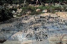
A wall painting that might depict the ancient Anatolian city of Çatalhöyük (previously known as Catal Huyuk or Çatal Hüyük) has been dated to the late 7th millennium BCE.
[1][2] Among the prehistoric alpine rock carvings of Mount Bego (France) and Valcamonica (Italy), dated to the 4th millennium BCE, geometric patterns consisting of dotted rectangles and lines are widely interpreted[3][4] in archaeological literature as depicting cultivated plots.
In the book Xin Yi Xiang Fa Yao, published in 1092 by the Chinese scientist Su Song, a star map on the equidistant cylindrical projection.
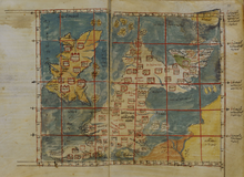
By combining the knowledge of Africa, the Indian Ocean, Europe, and the Far East (which he learned through contemporary accounts from Arab merchants and explorers) with the information he inherited from the classical geographers, he was able to write detailed descriptions of a multitude of countries.
As part of this work, a smaller, circular map depicting the south on top and Arabia in the center was made.
In 1492, Martin Behaim, a German cartographer and advisor to the king John II of Portugal, made the oldest extant globe of the Earth.
[23][24] In 1570, the Brabantian cartographer Abraham Ortelius, strongly encouraged by Gillis Hooftman, created the first true modern atlas, Theatrum Orbis Terrarum.
[28] Political leaders could lay claim to territories through the use of maps, and this was greatly aided by the religious and colonial expansion of Europe.
Map trade quickly shifted to Rome and Venice but then was overtaken by atlas makers in the late 16th century.
There were two main printmaking technologies in the Renaissance: woodcut and copper-plate intaglio, referring to the medium used to transfer the image onto paper.
To improve quality in the late fifteenth century, a style of relief craftsmanship developed using fine chisels to carve the wood, rather than the more commonly used knife.
Fine lettering is difficult in woodcut, where it often turned out square and blocky, contrary to the stylized, rounded writing style popular in Italy at the time.
Limning meant adding silver and gold leaf to the map to illuminate lettering, heraldic arms, or other decorative elements.
The map's depiction of trading routes, a compass rose, and scale bar points to the culmination of many map-making techniques incorporated into Chinese mercantile cartography.
Maps of the Enlightenment period practically universally used copper plate intaglio, having abandoned the fragile, coarse woodcut technology.
Due to the paucity of information and the immense difficulty of surveying during the period, mapmakers frequently plagiarized material without giving credit to the original cartographer.
De Fer, in turn, had copied images that were first printed in books by Louis Hennepin, published in 1697, and François Du Creux, in 1664.
[37] In the 20th century, aerial photography, satellite imagery, and remote sensing provided efficient, precise methods for mapping physical features, such as coastlines, roads, buildings, watersheds, and topography.
[38] Advances in electronic technology ushered in another revolution in cartography: ready availability of computers and peripherals such as monitors, plotters, printers, scanners (remote and document) and analytic stereo plotters, along with computer programs for visualization, image processing, spatial analysis, and database management, have democratized and greatly expanded the making of maps.
In the early years of the new millennium, three key technological advances transformed cartography:[39] the removal of Selective Availability in the Global Positioning System (GPS) in May 2000, which improved locational accuracy for consumer-grade GPS receivers to within a few metres; the invention of OpenStreetMap in 2004, a global digital counter-map that allowed anyone to contribute and use new spatial data without complex licensing agreements; and the launch of Google Earth in 2005 as a development of the virtual globe EarthViewer 3D (2004), which revolutionised accessibility of accurate world maps, as well as access to satellite and aerial imagery.
These advances brought more accuracy to geographical and location-based data and widened the range of applications for cartography, for example in the development of satnav devices.
In contemporary times, there is a resurgence of interest in the most beautiful periods of cartography, with various maps being created using, for example, Renaissance-style aesthetics.
[43] Field-rugged computers, GPS, and laser rangefinders make it possible to create maps directly from measurements made on site.
[44] An example of this understanding is that "[European reproduction of terrain on maps] reality can be expressed in mathematical terms; that systematic observation and measurement offer the only route to cartographic truth…".
[47] Maps furthered imperialism and colonization of Africa in practical ways by showing basic information like roads, terrain, natural resources, settlements, and communities.
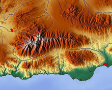
In the present era, one of the most widespread and advanced methods used to form topographic maps is to use computer software to generate digital elevation models which show shaded relief.
Although the most widely used map of "The Tube," it preserves little of reality: it varies scale constantly and abruptly, it straightens curved tracks, and it contorts directions.
[52] Modern technology, including advances in printing, the advent of geographic information systems and graphics software, and the Internet, has vastly simplified the process of map creation and increased the palette of design options available to cartographers.
Its purpose may be as broad as teaching the major physical and political features of the entire world, or as narrow as convincing a neighbor to move a fence.
Mount Richard, for example, was a fictitious peak on the Rocky Mountains' continental divide that appeared on a Boulder County, Colorado map in the early 1970s.