Afar Triangle
The lowlands are affected by heat, drought, and minimal air circulation, and contain the hottest places (year-round average temperatures) of anywhere on Earth.
Wildlife includes many herbivores such as Grévy's zebra, Soemmerring's gazelle, beisa and, notably, the last viable population of African wild ass (Equus africanus somalicus).
A fossilized almost complete skeleton of a female hominin which he named "Ardi", it took nearly 15 years to safely excavate, preserve, and describe the specimen and to prepare publication of the event.
The immediate consequences are recurring sequences of earthquakes with deep fissures in the terrain hundreds of metres long, and the valley floor sinking broadly across the depression.
During September and October 2005 some 163 earthquakes of magnitudes greater than 3.9 and a volcanic eruption occurred within the Afar rift at the Dabbahu and Erta Ale volcanoes.
Some 2.5 cubic kilometers of molten rock was injected from below into the plate along a dyke between depths of 2 and 9 km (1 and 6 mi), forcing open an 8 m (26 ft) wide gap on the surface, known as the Dabbahu fissure.
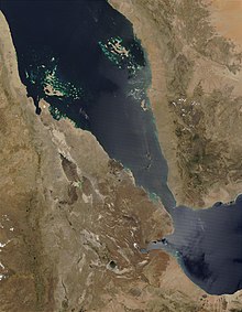
[8] Over the next millions of years, geologists expect erosion and the Red Sea to breach the highlands surrounding the Afar Depression and flood the valley.
Geologists predict that in about 10 million years the whole 6,000 km (3,700 mi) length of the East African Rift will be submerged, forming a new ocean basin as large as today's Red Sea, and separating the Somali plate and the Horn of Africa from the rest of the continent.