Agusan del Sur
It is third largest river in the country and served as highway for the Spanish colonizers in gaining access to inner northeastern Mindanao.
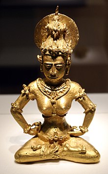
Agusans pre-Hispanic cultural history is traced back to the great influence of the Majapahit Empire through the discovery of an 8-inch (200 mm) tall image of a woman in pure gold at Maasam, Esperanza in 1917 and molten jars unearthed at Bah-bah, Prosperidad.
The aborigines of Agusan del Sur are the ancestors of the present day Mamanwas, who were driven to the hinterlands by waves of Malay immigrants.
These immigrants, in turn, sought the protection of the interior jungles because of the forays and the constant raids of the Moros, who were seafaring people confined to coastal areas where they started their settlements.
[citation needed] The territory of Agusan del Sur was governed as part of the province of Caraga during most of the Spanish period.
Visayan migrants settled in the cleared plains, pushing Indigenous communities farther into the mountainous slopes.
Archeological excavations in the lower Agusan valley plains have uncovered evidence of strong relationships between the region and the Southeast Asian states.
A golden image of Javan-Indian design unearthed in the 1920s and molten jars uncovered in Prosperidad are indications that the region had commercial and cultural ties with the coast.
The general headquarters and military camp and base of the Philippine Commonwealth Army was active from January 3, 1942, to June 30, 1946, and the 10th Infantry Regiment of the Philippine Constabulary was active again from October 28, 1944, to June 30, 1946, are military stationed in the province of Surigao was composed to engaging operations against the Japanese Occupation.
[clarification needed] During World War II, a unit of the joint Philippine-American defense force was located at Manot, Talacogon, in the interior of the Agusan Valley.
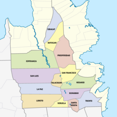
Agusan del Sur is an elongated basin formation with mountain ranges in the eastern and western sides forming a valley, which occupies the central longitudinal section of the land.
The climate map of the Philippines based on the modified coronas classification shows that the province falls under Type II.
The Agusan del Sur population is predominantly composed of migrants from the Visayas, who came from Cebu, Bohol, Siquijor and Negros Oriental as well as Cebuano-speaking parts of Mindanao.
There are also significant minority residents in the province whose descendants came from Ilocandia, Cagayan Valley, Cordillera Administrative Region, Central Luzon, Calabarzon, Mindoro, Marinduque, Bicolandia, Panay, Negros Occidental and Samar.
Other languages varyingly spoken in the province include Bohol Cebuano, Butuanon, Ilocano, Hiligaynon, Pangasinan, Surigaonon and Waray.
Poverty incidence of Agusan del Sur Source: Philippine Statistics Authority[14][15][16][17][18][19][20] Based on the 1995 census, 75% of the labor force is engaged in agriculture and forestry.
[citation needed] Coconut trees are widespread in the province, covering 393.36 square kilometres (151.88 sq mi).
[citation needed] Despite the government's efforts to increase poultry and livestock production, deficits in meat supply persist.
The term of office of Congressman Democrito O. Plaza would have continued until December 1973 had it not for the proclamation of Martial Law on September 21, 1972, which in effect abolished the Congress.
When the Interim Batasang Pambansa was convened in 1978 after almost a decade of absence under the martial Law, Edelmiro Amante represented the province in the National Assembly.