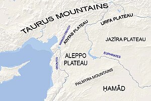
Aintab plateau
The plateau's average elevation is 800 meters, with peaks over 1000 m to the north-northwest and 375–600 m plains towards the south and east.
Aintab plateau is bounded from the east by the valley of the Euphrates River and the Manbij plain, and from the north by the Taurus Mountains.
Its eastern part is occupied by the plains of Tall Bashar (Oğuzeli), Yavuzeli, and Araban in Gaziantep Province.
The Alleben and Sajur rivers rise from Sof Mountain and flow southeast to the Euphrates across the plain of Tall Bashar.
The Merzimen (Bozatlı) river rises from Sof Mountain, flows through the southern part of the Yavuzeli Plain, and joins the Euphrates.
Their highest peaks are the Akdag (2552 m), Dibek (2549 m), Tucak (2533 m), Gorduk (2206 m), Nemrut (2150 m), Borik (2110 m), Bozdag (1200 m), and Karadag (1115 m).