Algiers Point
As the river reaches the downriver end of that crescent, flowing by then in a northerly direction, it makes a sharp "right-hand" turn to the east.
The French Quarter, Faubourg Marigny and Bywater lie on the outside of the bend on the river's left descending bank.
[5] Its geographic coordinates are 29°57′19″N 90°03′19″W / 29.95528°N 90.05528°W / 29.95528; -90.05528 The U.S. Army Corps of Engineers' linear description of the location is mile 94.6 AHP (above Head of Passes) on the Lower Mississippi River.
In the 20th century, the Coast Guard began regulating marine traffic approaching and rounding Algiers Point.
[8] [9] Numerous small businesses such as bars, restaurants, coffee shops, and professional services are located here, creating a mixed use neighborhood.
New Orleans Public Library (NOPL) operates the Cita Dennis Hubbell Branch in Algiers Point.
[13] It reopened shortly after Katrina, but when officials processed concerns about the structural integrity of the building they decided to close the library.

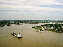
A downbound ship and other vessels on the Lower Mississippi River, with Algiers Point to the right

Late 19th-century houses at the corner of Delaronde and Olivier Streets

