Hurricane Katrina
Hurricane Katrina was a powerful and devastating tropical cyclone that caused 1,392 fatalities and damages estimated at $125 billion in late August 2005, particularly in the city of New Orleans and its surrounding area.
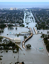
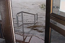
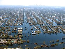
The flooding destroyed most of New Orleans's transportation and communication facilities, leaving tens of thousands of people who did or could not evacuate the city before landfall with little access to food, shelter, and other necessities.
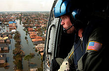
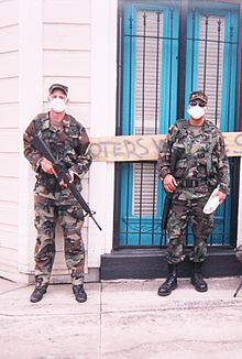
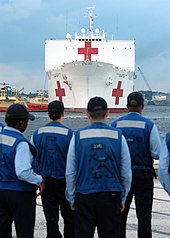
The disaster in New Orleans prompted a massive national and international response effort, including federal, local, and private rescue operations to evacuate those displaced from the city in the following weeks.
After the storm, multiple investigations concluded that the U.S. Army Corps of Engineers, which had designed and built the region's levees decades earlier, was responsible for the failure of the flood-control systems.
[5] After attaining Category 5 hurricane status on the morning of August 28, Katrina reached its peak strength at 1800 UTC, with maximum sustained winds of 175 mph (280 km/h) and a minimum central pressure of 902 mbar (26.6 inHg).
[16] The National Weather Service's New Orleans/Baton Rouge office issued a vividly worded bulletin on August 28 predicting that the area would be "uninhabitable for weeks" after "devastating damage" caused by Katrina, which at that time rivaled the intensity of Hurricane Camille.
[17] During video conferences involving the president later that day and on August 29, NHC director Max Mayfield expressed concern that Katrina might push its storm surge over the city's levees and flood walls.
[1] By Sunday, August 28, most infrastructure along the Gulf Coast had been shut down, including all freight and Amtrak rail traffic into the evacuation areas as well as the Waterford Nuclear Generating Station.
The hurricane made its final landfall near the mouth of the Pearl River, with the eye straddling St. Tammany Parish, Louisiana, and Hancock County, Mississippi, on the morning of August 29 at about 9:45 am.
As a result of the rainfall and storm surge the level of Lake Pontchartrain rose and caused significant flooding along its northeastern shore, affecting communities from Slidell to Mandeville.
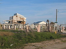
[76] Surge covered almost the entire lower half of Hancock County, destroying the coastal communities of Clermont Harbor and Waveland, much of Bay St. Louis, and flowed up the Jourdan River, flooding Diamondhead and Kiln.
In Harrison County, Pass Christian was completely inundated, along with a narrow strip of land to the east along the coast, which includes the cities of Long Beach and Gulfport; the flooding was more extensive in communities such as D'Iberville, which borders Back Bay.
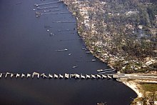
[54] Although Hurricane Katrina made landfall well to the west, Alabama and the Florida Panhandle were both affected by tropical-storm-force winds and a storm surge varying from 12 to 16 feet (3.7–4.9 m) around Mobile Bay,[4] with higher waves on top.
Wind gusts up to 60 mph (97 km/h) also impacted parts of Maine, felling trees and causing power outages in Bar Harbor, Blue Hill, Dover-Foxcroft, Sedgwick Ridge, and Sorrento.
[82] Severe local flooding occurred in Quebec, forcing the evacuations of dozens of homes in some communities as rivers began overflowing their banks and sewage systems were becoming overwhelmed by the influx of precipitation.
The Bush administration sought $105 billion for repairs and reconstruction in the region,[85] which did not account for damage to the economy caused by potential interruption of the oil supply, destruction of the Gulf Coast's highway infrastructure, and exports of commodities such as grain.
[44] These residual waters contained a mix of raw sewage, bacteria, heavy metals, pesticides, toxic chemicals, and oil, which sparked fears in the scientific community of massive numbers of fish dying.
Thomas La Point, director of the Institute of Applied Sciences at the University of North Texas, stated that "[a] toxic soup would be a good way to describe the situation".
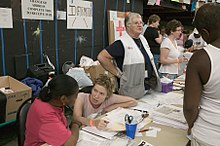
[118] Some disaster relief response to Katrina began before the storm, with the Federal Emergency Management Agency (FEMA) preparations that ranged from logistical supply deployments to a mortuary team with refrigerated trucks.
Michael Chertoff, Secretary of the Department of Homeland Security, decided to take over the federal, state, and local operations officially on August 30, 2005, citing the National Response Plan.
Criticism was initially prompted by televised images of visibly shaken and frustrated political leaders, and of residents who remained stranded by floodwaters without water, food, or shelter.
Deaths from thirst, exhaustion and violence days after the storm had passed fueled the criticism, as did the dilemma of the evacuees at facilities such as the Louisiana Superdome and the New Orleans Civic Center.
Nagin and Blanco were criticized for failing to implement New Orleans's evacuation plan and for ordering residents to a shelter of last resort without any provisions for food, water, security, or sanitary conditions.
The storm's devastation also prompted a congressional investigation, which found that FEMA and the Red Cross "did not have a logistics capacity sophisticated enough to fully support the massive number of Gulf coast victims".
[149] The Bush administration announced in mid-September that it did not need Israeli divers and physicians to come to the United States for search and rescue missions, but a small team landed in New Orleans on September 10 to give assistance to operations already underway.
[152] The American Red Cross, America's Second Harvest (now known as Feeding America), Southern Baptist Convention, Salvation Army, Oxfam, Common Ground Collective, Burners Without Borders,[153] Emergency Communities, Habitat for Humanity, Catholic Charities, Direct Relief, Service International, "A River of Hope", The Church of Jesus Christ of Latter-day Saints,[154][155][156] and many other charitable organizations provided aid to victims in the aftermath of the storm.
[165] According to a modeling exercise conducted by the U.S. Army Corps of Engineers (USACE), two-thirds of the deaths in Greater New Orleans were due to levee and flood wall failure.
"[167] A June 2007 report released by the American Society of Civil Engineers determined that the failures of the levees and flood walls in New Orleans were found to be primarily the result of system design and construction flaws.
According to the authors of Catastrophe in the Making (Island Press, 2009), the straight design and lack of outward flow into the Gulf allowed the Mississippi River-Gulf Outlet Canal to become "the perfect shortcut for salt-water intrusion", which damaged buffering cypress forests and wetlands that historically had protected New Orleans from storm surge.
One illustration was when Geraldo Rivera of Fox News tearfully pleaded for authorities to either send help or evacuate the thousands of evacuees stranded at the Ernest N. Morial Convention Center.

Tropical storm (39–73 mph, 63–118 km/h)
Category 1 (74–95 mph, 119–153 km/h)
Category 2 (96–110 mph, 154–177 km/h)
Category 3 (111–129 mph, 178–208 km/h)
Category 4 (130–156 mph, 209–251 km/h)
Category 5 (≥157 mph, ≥252 km/h)
Unknown