Altai Republic
It is a part of the Siberian Federal District, and covers an area of 92,903 square kilometers (35,870 sq mi), with a population of 210,924 residents.
During the Qing administration, the General of Siberia Fedor Ivanovich Soimonov launched a non-military expedition into the Altan Nuur region in 1760 and began fort building.
[12] During the Russian Civil War, the Confederated Republic of Altai (Karakorum-Altai Region) was established in 1918, and declared as the first step to rebuilding Genghis Khan's Mongol Empire.
[13] But it never became a competing force in the Russian Civil War, and stayed neutral from 1918 until January 1920, when it was annexed back into Russia.
[13] On June 1, 1922, the Altaians regained autonomy with the creation of the Oyrot Autonomous Oblast (Ойро́тская автоно́мная о́бласть), part of Altai Krai.
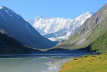
The emerald-colored Katun River has its source at the Gebler glacier, which is situated on the Republic's highest point, Mount Belukha.
The Katun River, in particular, holds a religious significance for native Altaians, as well as for many Russians who live in the area, as Mount Belukha is known in Altai folklore to be the gateway to the mystical kingdom of Shambhala.
[14] The hydrographic network of the Republic also includes approximately 7,000 lakes, adding up to a total area of more than 700 km2 (270 sq mi).
The mountain lakes of Altai contain enormous freshwater reserves of a very pure quality as a result of their distance from civilization.
The total water stock of the glaciers exceeds the average annual effluence of all Altai rivers, which are equal to 43 km3 per year.
The republic has a temperate continental climate with relatively short and mild summers (June–August); and long, cold, and often quite frosty winters (November–March).
However, it does have some industry which includes foodstuffs, non-ferrous metallurgy, chemicals, gold mining, footwear, dairying, and timber.
The main paved road is the Chuysky Tract, which spans the republic from the capital Gorno-Altaisk in the north to the Mongolian border in the south.
They are also almost entirely located along the Chuiskiy highway, which is the main road from the north into the mountains, although it is currently (2006) only two lanes wide.
6% of the population follows Islam, 2% Hinduism (including Slavic-Vedic, Krishnaite, and Tantric movements), 1% are Old Believers and 1% Protestants.
[27] From 1904 until the 1930s, a new religious movement called Burkhanism (or Ak Jang, the "white faith") was popularized among native Altaians.
One can often find manifestations of shamanistic spirituality in the region; for example, at points along the Katun River, local believers in shamanic religions are known to tie white ribbons to nearby trees and leave offerings of coins or food to the spirits.
[28] Although shamanism is much less widely practiced today, it is regaining popularity as a result of new religious freedom following the collapse of the Soviet Union.
There is also a large contingent of "Old Believers" who fled to Altai when they split from the Russian Orthodox Church over 300 years ago.
The UNESCO World Heritage Site "Golden Mountains" protects the Ukok Plateau, on which there are many standing stones and kurgans.
Although archaeologists consider kurgans to be burial sites, the indigenous people believe that they are highly refined magnetic instruments for directing the flow of cosmic energy into the Earth.
[citation needed] Thus, there is great local indignation about the excavation and removal of the Siberian Ice Maiden, an extraordinary 2,500-year-old mummy that had been preserved in permafrost.
Regularly held national holiday Maslenitsa, Nowruz, Chaga – Bayram, received in February 2013 with the official status of the Republican celebration.