Amazon biome
Some areas of the biome are threatened by deforestation for timber and to make way for pasture or soybean plantations.
[2][a] The biome roughly corresponds to the Amazon basin, but excludes areas of the Andes to the west and cerrado (savannah) to the south, and includes lands to the northeast extending to the Atlantic ocean with similar vegetation to the Amazon basin.
[2] J. J. Morrone (2006) defines the Amazonian subregion in this broader sense, divided into the biogeographical provinces of Guyana, Humid Guyana, Napo, Imeri, Roraima, Amapá, Várzea, Ucayali, Madeira, Tapajós-Xingu, Pará, Yungas and Pantanal.
[6] The biome covers parts of Brazil, Bolivia, Peru, Ecuador, Colombia, Venezuela, Guyana, Suriname and French Guiana.
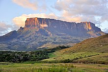
[10] The Amazon basin is crossed by ridges or "paleoarches" that connect the Guiana and Central Brazil shields and divide it into geological sub-basins.
Thus the Iquitos arch is considered the main reason for the different species of frogs and rodents and different forest types on either side of the ridge.
Thus the Rio Negro ("Black River") has clear, jet-black water caused by decomposition of organic matter in swamps along its margins, combined with low levels of silt.
[18] The Amazon and its major tributaries such as the Xingu, Tapajós, Madeira, Purus and Rio Negro form barriers to the geodispersal of plants, animals and even insects.
[19] The World Wildlife Fund divides the biome into ecoregions, often defined as the regions lying between major tributaries of the Amazon.
[6] The Amazon biome contains areas of other types of vegetation including grasslands, swamps, bamboos, and palm forests.
[24][2] In the southwest Amazon at least 161,500 square kilometres (62,400 sq mi) of forest are dominated by bamboos.
These occur in areas where there has been recent tectonic uplift combined with fast mechanical erosion and poor drainage.
In each patch of bamboos all the plants flower every 27–28 years, producing huge numbers of seeds, before dying.
[26] Before Ghillean Prance's 1979 study, the local people and many scientists called the permanently waterlogged swamp on the lower Amazon "igapó" and all types of periodically flooded land "várzea".
[27] A more recent definition, from Prance, is:[28] Major flooded areas include the Iquitos, Purus, Monte Alegre, Gurupa and Marajó várzeas.
[34] Patches of campinarana, which may cover several thousand square kilometres, are found in the transitional region from the Guyana Shield to the Amazon basin.
[35] Campinarana is typically found on leached white sands around circular swampy depressions in lowland tropical moist forest.
[34] The savannah is mainly composed of grasses and lichens, found in the wet plains beside lakes and rivers.
[36] The scrub has bare sand, herbaceous plants, shrubs and trees less than 7 metres (23 ft) high.
The land behind the dunes may include dwarf palms, bromeliads, ferns, shrubs, grasses and scrub trees.
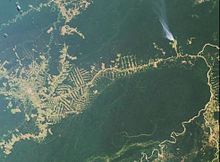
[39] More than 15,000 square kilometres (5,800 sq mi) of the Brazilian Amazon biome was deforested in 2008–12, of which only 6% took place within protected areas.
[46] Satellite images show that in the 2006–11 period total deforestation in the Amazon biome was 45,100 square kilometres (17,400 sq mi), of which 34,700 hectares (86,000 acres) were in the three soy-producing states of Mato Grosso, Para and Rondonia.
[52] In 2010 a presidential decree made low-interest credit available to oil palm development, but only on land that had been deforested before 2008.