Northern United States
Before the 19th century westward expansion, the "Northern United States" corresponded to the present day New England region.
By the 1830s it corresponded to the present day Northeast and Great Lakes region.
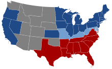
There is, however, some historical disagreement as to exactly which states comprised the North in the context of the Civil War as five slave-holding states largely remained with the Union: the southern border states of Missouri, Kentucky, West Virginia, Maryland, and Delaware, along with the disputed Indian Territory, though Missouri and Kentucky had dual competing Confederate and Unionist governments with the Confederate government of Kentucky and the Confederate government of Missouri and the Confederacy controlled more than half of Kentucky and the southern portion of Missouri early in the war.
[7] The U.S. Census Bureau also includes the northernmost states of the Northwest, that are within the West Region.
Most of the Northern states have warm to hot summers and significant snowfall during the winter.