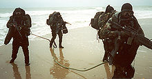
Amphibious reconnaissance
At the turn of the 20th century, amphibious reconnaissance was first conceived from an idea from a United States Marine officer by then-Major Dion Williams.
The scope of the doctrine outlined every aspect that involved recognition of intelligence gathering and planning, the cornerstone of America's present-day methods in amphibious reconnaissance.
Williams' doctrine outlined a wide spectrum of reconnaissance, which consisted of range determination, topography, configuration of the ground, cities, towns, roads, trails, railroads, telegraph cables, telephone lines, wireless telegraphy, rivers, canals, resources (coal, repair facilities, land transportation, electric plants, food supplies, water supply, and hospitals), conditions of the harbor and harbor steamers, wharves, docks, water service, the population (secret service, professions and occupations, naval and military forces), existing defenses (location, form and description, armament, fieldworks, mines and mine fields, searchlights, plans and sketches, garrisons and forces available, methods of attack, adaptability of the defenses).
[4] In order to prepare intelligent plans for the attack or defense of a harbor or bay, it is necessary to have at hand a comprehensive description of the hydrographic features and accurate charts showing the depths of water at all points, the reefs, rocks, shoals, and peculiar currents which constitute dangers to navigation, and the tributary streams and channels which may form avenues of attack or furnish anchorages for a portion of the floating defenses or auxiliaries of the defenders.
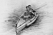
Commander Nigel Clogstoun-Willmot RN, who developed what would become the Combined Operations Pilotage Parties (COPPs) while conducting raids on the Aegean Islands in 1941.
In preparation for the invasion of Normandy, the British carried out Operation Postage Able, in which a midget submarine took a team close in to the planned landing sites.