Amud
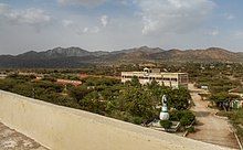
The archaeological site is situated 1,000 metres (3,300 ft) above sea level, around 10 km southeast of the regional capital Borama.
[3][4] Archaeologist Jorge Rodriguez states that this town, similar to other ruins in the area, originates from the 15th century and is associated with the Adal Sultanate.
There is a mosque in the southern half of the dwelling area... [with a] rather oddly built mihrab facing the entrance... and immediately to the south... is the cemetery.
There was also a considerable quantity of the currency beads used along the African coast and in the interior, some of which I am inclined to believe to be of European manufacture and not earlier than the beginning of the 19th century."[8]Dr.
It lay between Aw Barreh and Abassa on the road from Harar to Zeila which was also the caravan route between the cities of the Upper Niger and the Gulf of Tajura.
[10] The old section of Amud spans 25 acres (100,000 m2) and contains hundreds of ancient ruins of multi-roomed courtyard houses, stone walls, complex mosques, and other archaeological remains, including intricate colored glass bracelets and Chinese ceramics.
Huntingford noticed that whenever a historic site had the prefix Aw in its name (such as the ruins of Awbare and Awbube), it denoted the final resting place of a local Saint.