Anahim Volcanic Belt
The Anahim Volcanic Belt (AVB) is a west–east trending chain of volcanoes and related magmatic features in British Columbia, Canada.
It consists mainly of alkaline to peralkaline rocks that range from oversaturated, highly evolved phonolites and rhyolites to more undersaturated lavas.
In some places the AVB lavas imperceptibly merge with the Chilcotin Group basalts as the two volcanic zones were active simultaneously from the Neogene to Quaternary.
[1][2][3][4] Its orientation is unique among the Neogene–Quaternary volcanic provinces of British Columbia in that it is perpendicular to the major geomorphological, structural and tectonic elements of the Canadian Cordillera.
[1] The generally preferred tectonic model is a mantle hotspot as the AVB decreases in age from west to east, a trend that is consistent with the westward motion of North America at the rate of about 2.5 cm (0.98 in) per year.
The youngest basalts are undersaturated alkaline lavas and are classified as basanite, suggesting a deeper source zone for magma in the Nazko area compared to the rest of the AVB.
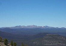
[1] The Rainbow Range is a 30 km (19 mi) diameter, moderately dissected shield volcano that was active 8.7 to 6.7 million years ago.
[4][9] Four volcanic episodes characterized by highly fluid alkaline and peralkaline lava flows created an 845 m (2,772 ft) thick assemblage exposed on the north flank.
Late stage volcanism resulted in the creation of scattered hawaiite dikes, plugs and minor capping flows over the north flank.
[4] Accompanying the northeastern flank is Anahim Peak, a trachyte plug surrounded by a pile of hawaiite flows that are four to eight times thicker than those of the Rainbow Range.
[9] To the east lies the Ilgachuz Range, a slightly smaller and less deeply dissected shield volcano that formed 6.1 to 4.0 million years ago.
[5] Its nearly circular and gently sloping structure, 25 km (16 mi) in diameter, consists of four assemblages that were deposited in six major episodes of activity.
[6] The Satah Mountain volcanic field is a linear region of cones and domes extending 50 km (31 mi) south from the Itcha Range to just north of Chantslar Lake.
The second episode is constituted by a subglacial mound of hyaloclastite that formed under the Cordilleran Ice Sheet, perhaps during the Fraser Glaciation which took place between 25,000 and 10,000 years ago.
Radiocarbon dating of bog peat above and below a tephra layer near Nazko Cone suggest that the latest eruption took place about 7,200 years ago.
[12] From 9 October 2007 to 15 May 2008, a series of earthquakes measuring up to 2.9 magnitude occurred in the Nechako Basin about 20 km (12 mi) west of Nazko Cone.
Analysis of seismic waves suggest that the earthquake swarm was caused by brittle failure and fracturing of rock at depth from magma intrusion.
Although these volcano tectonic earthquakes were too small to be felt, they generated substantial local interest as they represented a significant concentration of seismic activity within the Anahim Volcanic Belt.