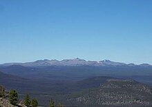
Itcha Range
More than 15 animal species are known to exist in the Itcha Range area, as well as a grassland community that is limited only to this location of British Columbia.
This highly dissected volcanic edifice consists of a variety of rock types, including basanite, hawaiite, trachyte, rhyolite, phonolite and alkali olivine basalt.
[5] The climate of the Itcha Range is influenced by the presence of the Coast Mountains to the west, which disrupt the flow of the prevailing westerly winds and causes them to drop most of their moisture on the western slopes of the Coast Mountains before reaching the Interior Plateau, casting a rain shadow over the Itcha Range.
Also present is the largest herd of woodland caribou in southern British Columbia, as well as the most northerly population of California bighorn sheep in North America.
This includes rift propagation and melting of mantle associated with lithospheric fracturing due to flexuring of the crust along the northern edge of the subducting Juan de Fuca Plate.
[10] The Anahim hotspot is underlain by a low-velocity anomaly that extends approximately 400 km (250 mi) into the mantle north of the Juan de Fuca slab.
Coupled with the well documented temporal progression of surface volcanism, this has led to the conclusion that the Anahim hotspot is supplied by a mantle plume over slab edge flow.
A small high-velocity anomaly east of Nazko Cone marks the eastern extent of the Anahim hotspot track.
[10] Magmatism in the Anahim Volcanic Belt can be traced as far back as 10–14 million years ago with the emplacement of dike swarms and plutons as well as the eruption of rhyolite flows and breccias on the British Columbia Coast.
The slow continuous westward motion of the North American Plate during the late Neogene positioned the Anahim hotspot further east at the Chilcotin Plateau where volcanic activity built the Rainbow Range shield volcano 8.7 to 6.7 million years ago.
Volcanism then shifted eastwards, in displacement contrary with the North American Plate's movement, 6.1 million years ago to construct the Ilgachuz Range shield volcano.
[11] The Itcha Range continued to be an area of Anahim hotspot volcanism well into the Quaternary period (2.58 million years ago to present).
[12] The Itcha Range is the smallest shield volcano in the Anahim Volcanic Belt in terms of area covered.
[13] Exposed in the middle of the mountain range is an assemblage of deformed andesite to dacite lava flows and volcanoclastic sediments.
Analysis of the first trachyte magmas to erupt during the pre-explosive phase suggest they were relatively fluid as shown by their areal extent.
The increasing viscousness of felsic lava during the shield-building stage suggests a maturing plumbing system underneath the Itcha Range, which may have consisted of multiple, isolated, cupola-type magma chambers.
However, the associated hawaiite lavas may have derived from an alkali olivine basalt parent by the fractionation of a clinopyroxene-dominated assemblage at higher pressures.
If volcanic activity of the Itcha Range is related to a hotspot, this temporal and spatial evolution would suggest a waning heat source.
A hydrothermally altered aphyric trachyte dike, which forms a narrow ridge linking Mount Downton and Itcha Mountain, might have been the source for these eruptions.
The final volcanic event of the post-explosive phase produced 7 to 10 m (23 to 33 ft) thick trachyte lava flows on the western flank.
[3] During the mafic capping stage, basanite, alkali olivine basalt and hawaiite erupted mainly from small parasitic cones, tuff rings and fissures in the eastern half of the shield.
[3][14] Eruptions occurred subglacially, subaqueously and/or subaerially as shown by a wide range in the degree of vesicularity, freshness and glass content of the lavas.
Hawaiite was the most extensively erupted lava of the mafic capping stage, occurring mostly at the southern end of the Itcha Range but also in its interior.
Alkali olivine basalts were erupted contemporaneously from younger better preserved cinder cones and form lava flows reaching 30 m (98 ft) thick.
[3] Parasitic cones of the Itcha Range shield were formed mainly during the Early Pleistocene mafic capping stage between 2.2 and 0.8 million years ago.
[40] Mount Downton was named by D. M. MacKay, a member of the British Columbia Land Surveyors (BCLS) who conducted topographical surveys in the area.
[41] He named it after Geoffrey M. Downton, another BCLS member who is credited for first noting the hydroelectric potential inherent in the elevation differential between the Bridge River and Seton Lake on opposing sides of Mission Ridge above Shalalth in December 1912.
[8] The Itcha Range and the surrounding area were designated as a Class A provincial park in 1995 to protect the alpine grasslands, wetlands and wildlife habitats.
[7] Like other volcanoes in the Anahim Volcanic Belt, the Itcha Range is not monitored closely enough by the Geological Survey of Canada to ascertain how active its magma system is.
The Canadian National Seismograph Network has been established to monitor earthquakes throughout Canada, but it is too far away to provide an accurate indication of activity under the range.