Anahim hotspot
This theory proposes that a single, fixed mantle plume builds volcanoes that then, cut off from their source by the movement of the North American plate, become increasingly inactive and eventually erode over millions of years.
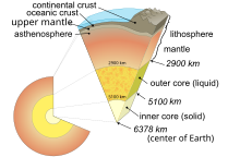
Tomographic imaging has since identified a low-velocity anomaly, indicative of an upwelling plume, that measures roughly 400 kilometres (250 miles) deep.
[3] According to Wilson's theory, the Anahim volcanoes should be progressively older and increasingly eroded the further they are from the hotspot and this is easily observable; the oldest rock on coastal British Columbia, that of the Gale Passage dike swarm, is about 14.5 million years old and deeply eroded, while the rock at Nazko Cone, the hotspot's present centre, is a comparatively young 0.34 million years of age or less.
[3][4] Radiocarbon dating of peat directly above and below a tephra layer extending 4 kilometres (2.5 miles) from Nazko Cone suggest that the latest eruption occurred approximately 7,200 years ago.
This heated, buoyant and less-viscous portion of the upper layer would become less dense due to thermal expansion and rise towards the surface as a Rayleigh-Taylor instability.
The presence of two hotspot tracks on the same continent and their general agreement between each other provides a unique tool in assessing and testing the motion of North America.
This included a hotspot and a propagating crack controlled by stress fields related to large-scale plate tectonics of western North America.
It was also noted that the trace and rare-earth element patterns of mafic lavas in the Anahim Volcanic Belt are similar to ocean island basalts, providing more evidence for a hotspot.
In the north, high-velocities may reflect the remains of batholithic roots that formed as a result of continuous subduction along the northern continental margin 150 to 50 million years ago.
Therefore, it remains unknown if the hotspot existed in the Pacific Ocean prior to being located on the North American continent from ongoing plate motion.
However, further analyses of Masset volcanic rocks are still required to determine if they are compositionally and istopically similar to alkalic lavas found on the mainland.
Volcanic activity 14.5 to 3.0 million years ago was predominately felsic, producing large volumes of rhyolite and trachyte lava.
[3][4] This can be explained by the presence of thick granitic structures under these volcanoes, which have been tectonically compressed from being near the North American plate margin.
For instance, much of the magma created between 3.0 and 0.33 million years ago was igneous phonolite, trachyte, trachyandesite, basalt and basanite; the volcanoes built during this period are almost entirely made of these rock types.
[7] Basanites produced by these eruptions are significantly more undersaturated than basalts from older Anahim volcanoes in the west and may indicate an eastward shift toward a deeper or less depleted mantle source.
Their outer slopes merge with older flat-lying basalt flows of the Chilcotin Group, which covers a large percentage of the Interior Plateau.
In contrast, lava domes are formed mainly by viscous trachytic magma that erupts effusively onto the surface and then piles up thick around vents.
The initial shield stage is the most productive volcanically and features repeated eruptions of large volumes of predominately fluid peralkaline felsic magmas that become progressively more evolved.
[4] Rifting and crustal extension in Queen Charlotte Sound up to about 17 million years ago has been linked to the Early Miocene passage of the Anahim hotspot.
Yorath and Chase (1981) proposed that subcrustal melting above the Anahim plume resulted in weakening of the regional crust, setting the stage for rift development.
Later, widespread volcanism produced subaerial basalt and rhyolite flows in the region of the rift and along transcurrent faults that extend towards the northwest.
Haida Gwaii was displaced approximately 70 kilometres (43 miles) to the north along a series of faults extending through Sandspit and Louscoone Islet.
[20] This suggests that the uplift could have been thermally driven by the Anahim hotspot, which thinned the lithosphere and caused changes in sub-crustal and surface heat flux.
[7][21] About 1 kilometre (0.62 miles) of uplift was achieved during the hotspot's time in the south-central Coast Mountains over a period of a few million years.
This complexity may have given rise to interactions of the hotspot with pre-existing fracture systems, such that magma rose along normal faults to create a 50-kilometre-long (31-mile) north–south trending chain of volcanoes.
A lack of extensive volcanic fields adjacent to the neighbouring Ilgachuz and Rainbow ranges might indicate an absence of fracture systems associated with those volcanoes.
[7][22] From October 9, 2007, to May 15, 2008, a series of earthquakes measuring up to 2.9 magnitude occurred in the Nechako Basin some 20 kilometres (12 miles) west of Nazko Cone.
Analysis of seismic waves suggest that the earthquake swarm was caused by brittle failure and fracturing of rock at depth from magma intrusion.
[23] Although these earthquakes were too small to be felt, they generated substantial local interest as they represented a significant concentration of seismic activity within the Anahim Volcanic Belt.
[24] This has led to the possibility of a volcanic geothermal system, the existence of which has been investigated by Geoscience BC as part of their Targeting Resources for Exploration and Knowledge project.