Ancient maritime history
[9][10] By the time of Julius Caesar, several well-established combined land-sea trade routes depended upon water transport through the sea around the rough inland terrain features to its north.
Remains of stone tools and marine shells in Liang Sarru, Salibabu Island, North Sulawesi, dated to 32,000–35,000 years ago, is possible evidence for the longest sea voyage by Paleolithic humans ever recorded.
[13][14][15] The sea crossing by humans to the Sahul landmass (modern Australia and New Guinea) from the Sundaland peninsula occurred around 53,000 to 65,000 years ago.
[8] The acquisition of the catamaran and outrigger boat technology by the non-Austronesian peoples in Sri Lanka and southern India is the result of very early Austronesian contact with the region, including the Maldives and Laccadive Islands.
[23][24]: 38–42 At the furthest extents of the Austronesian expansion, colonists from Borneo crossed the Indian Ocean westward to settle in Madagascar and the Comoros by around 500 AD.
[29]: 10 Māori people of New Zealand are said to have Navigated following the zodiacal constellation of Scorpio, between Libra and Sagittarius in the southern sky positioned at about 16 hours 30 minutes right ascension and 30° south declination to find, Aotearoa, "The Land of the Long, White, Cloud".
Ancient maritime routes usually began in the Far East or down river from Madhya Pradesh with transshipment via historic Bharuch (Bharakuccha), traversed past the inhospitable coast of today's Iran then split around Hadhramaut into two streams north into the Gulf of Aden and thence into the Levant, or south into Alexandria via Red Sea ports such as Axum.
Each major route involved transhipping to pack animal caravan, travel through desert country and risk of bandits and extortionate tolls by local potentiates.
"And I ordered to build twelve warships with rams, dedicated to Amun or Sobek, or Maat and Sekhmet, whose image was crowned best bronze noses.
And blocked Our Majesty ship inside three partitions (bulkheads) so as not to drown it by ramming the wicked, and the sailors had time to repair the hole.
and they have (carried) on the nose three assault heavy crossbow arrows so they lit resin or oil with a salt of Seth (probably nitrate) tore a special blend and punched (?)
and long ship seventy five cubits (41m), and the breadth sixteen, and in battle can go three-quarters of iteru per hour (about 6.5 knots)..." The text of the tomb of Amenhotep I (KV39).
[35] According to the Greek historian Herodotus, Necho II sent out an expedition of Phoenicians, which reputedly, at some point between 610 and before 594 BC, sailed in three years from the Red Sea around Africa to the mouth of the Nile.
He suggests that "It is extremely unlikely that an Egyptian king would, or could, have acted as Necho is depicted as doing" and that the story might have been triggered by the failure of Sataspes' attempt to circumnavigate Africa under Xerxes the Great.
The city states of Mossylon, Opone, Malao, Mundus and Tabae in Somalia engaged in a lucrative trade network connecting Somali merchants with Phoenicia, Ptolemic Egypt, Greece, Parthian Persia, Saba, Nabataea and the Roman Empire.
In Greek mythology, the Argonauts were a band of heroes who, in the years before the Trojan War, accompanied Jason to Colchis in his quest to find the Golden Fleece.
[48] The periplus, literally "a sailing-around', in the ancient navigation of Phoenicians, Greeks, and Romans was a manuscript document that listed in order the ports and coastal landmarks, with approximate distances between, that the captain of a vessel could expect to find along a shore.
[51] Northward and westward all secure radiocarbon dates are identical to those for Iberia c. 5500 cal BC, which indicates a rapid spread of cardium and related cultures: 2,000 km from the gulf of Genoa to the estuary of the Mondego in probably no more than 100–200 years.
[52] In Ionia (the modern Aegean coast of Turkey) the Greek cities, which included great centres such as Miletus and Halicarnassus, were unable to maintain their independence and came under the rule of the Persian Empire in the mid-6th century BC.
By the end of the third war, after the deaths of many hundreds of thousands of soldiers from both sides, Rome had conquered Carthage's empire and razed the city, becoming in the process the most powerful state of the Western Mediterranean.
This network later included parts of Vietnam, Malaysia, Indonesia, Thailand, and other areas in Southeast Asia where these jade ornaments, along with other trade goods, were exchanged (also known as the Sa Huynh-Kalanay Interaction Sphere).
[61][62][63][7][64] These early contacts resulted in the introduction of Austronesian crops and material culture to South Asia,[62] including betel nut chewing, coconuts, sandalwood, domesticated bananas,[62][61] sugarcane,[65] cloves, and nutmeg.
[7][62] During this period, the distribution of Austronesian trade goods like kapur barus and cloves also reached beyond South Asia to ancient Egypt and the Roman Empire.
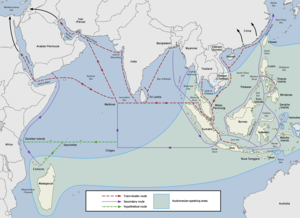
[70] The main route of the western regions of the Maritime Silk Road directly crosses the Indian Ocean from the northern tip of Sumatra (or through the Sunda Strait) to Sri Lanka, southern India and Bangladesh, and the Maldives.
Secondary routes also pass through the coastlines of the Bay of Bengal, the Arabian Sea, and southwards along the coast of East Africa to Zanzibar, the Comoros, Madagascar, and the Seychelles.
Books written by Chinese monks like Wan Chen and Hui-Lin contain detailed accounts of the large trading vessels from Southeast Asia dating back to at least the 3rd century CE.
[80] The Butuan boat burials of the Philippines, which feature eleven lashed-lug boat remains of the Austronesian boatbuilding traditions (individually dated from 689 CE to 988 CE), were found in association with large amounts of trade goods from China, Cambodia, Thailand (Haripunjaya and Satingpra), Vietnam, and as far as Persia, indicating they traded as far as the Middle East.
[60][84][85] In the Indian maritime history, the world's first tidal dock was built in phase II of Lothal[86][87] during the Harappan civilisation near the present day Mangrol harbour on the Gujarat coast.
Emperor Chandragupta Maurya's Prime Minister Kautilya's Arthashastra devotes a full chapter on the state department of waterways under nāvādhyakṣa (Sanskrit for Superintendent of ships) [1].
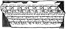
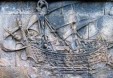
The galley was a long, narrow, highly maneuverable ship powered by oarsmen, sometimes stacked in multiple levels such as biremes or triremes, and many of which also had sails.